November 18, 2015
Entire study is available in PDF format (6 MB)
The MH17 Shootdown – Origin of Equipment and Military Control of the Area of the Zaroshchens’ke Ukrainian Armed Forces BUK Deployment
Abstract
This paper investigates the feasibility of the Russian Ministry of Defense’s allegation that BUK-M1 missile launchers were deployed by the Ukrainian Armed Forces to Zaroshchens’ke village near Shakhtersk in Ukraine’s Donetsk Oblast within firing range of the flightpath of Malaysian Airlines flight MH17. The path of Ukraine’s BUK-M1 units is traced from their leaving their bases up through their physicial disposition in mid-July of 2014. By examining on-line military operational reports of the Donbass Conflict from
Julyand August of 2014 from the Ukrainian Armed Forces and the Self-Defense Militia of the self-proclaimed Donetsk National Republic regarding the military situation between Ilovaisk and Saur Mogila, as well as social media posts by local residents, a coherent picture is uncovered which places this region in the control of the Ukrainian military from July 15 up to August, 21, 2014. Using this data, on-line satellite imagery of the region of the BUK-M1 site reported by the Russian Ministry of Defense near Zaroshchens’ke is examined, and military features seen in the imagery are interpreted in light of the military reports. Eyewitness interviews and social media posts are reviewed describing a rocket launch from near Shakhtersk. The paper concludes the deployment shown by Russian satellite imagery was militarily feasible because Ukraine controlled and had access to the territory in question, Ukrainian BUK vehicles were in the area, and local residents may have witnessed a launch. This confirms the government of Ukraine is a potential culprit in the shootdown of the civilian airliner MH17.
************************************************************************************************
About author Andrew
Background: American, Civil Engineer, work for American engineering company.
Motivation: To see justice done for victims of the MH17 air disaster. Long time interest in Ukraine developed through contacts with the immigrant Ukrainian Catholic community in the United States. As an American, sympathetic to anyone struggling for national self-determination and a life and government free from corruption.
Russian Language Translation Assistance: Sergey Mastepanov. All errors in Russian translation found by the reader are the fault of the primary author.
***********************************************************************************************
Introduction
As the MH17 tragedy unfolded on July 17, 2014, a narrative was quickly distributed out of Washington, DC and Kiev, Ukraine via the United States Embassy in Kiev and the Security Service of Ukraine (SBU). This narrative stated that the Boeing 777 airliner had been shot down with a powerful surface-to-air missile (SAM) fired from a BUK-M1 air defense vehicle by members of the Russian military and a rebel insurgent group operating under the name of the Самооборона Oполчение Донецкая Народов Республики – The Self-Defense Militia of the Donetsk National Republic (they will be referred to simply as
the Militia in this paper) within territory under their military control. The military forces of the self-proclaimed Donetsk National Republic (DNR) and Lugansk National Republic (LNR) were then undertaking a joint major armed rebellion within the Donetsk and Luhansk Oblasts of Ukraine (Donbass) against the new central state authorities of Ukraine, who had invaded these Oblasts in April using military units from central and western Ukraine. It was soon further alleged that the SAM was launched from the region of the city of Snizhne in the east of Donetsk Oblast from a BUK-M1 vehicle the Militia had obtained from Russia and thus presumably either officially from the Russian State and its Armed Forces or at least with their tacit approval using a captured vehicle (such as from Crimea or perhaps captured during the South Ossetian/Georgian War of 2008).
The outline and evidence of this joint Militia/Russian shootdown scenario has been extensively investigated, discussed and dissected over the past year by a variety of interested parties in the Western Press, on the Internet, and through official government statements. This paper will not address this scenario further. Instead, this paper investigates evidence for a scenario developed by the Russian Ministry of Defense (MoD) and elements of the Russian media and military-industrial complex.
In the immediate days during the initial presentation of evidence against the Militia and Russia, there was a growing sense of outrage in the world community. This was expressed through the Western and Malaysian press and government officials and from relatives and friends of the victims of shootdown, especially in the Netherlands and Australia, when both the Militia and/or the Russian government failed to offer the expected admission of responsibility for firing the missile at what they were supposed to have
thought was a military transport and apologize to the survivors of the victims for their accidentally becoming casualties of the civil war in the Donbass.
Instead, starting on the evening of July 17, the Russian MoD began releasing information in its possession related to the disposition of Ukraine’s own BUK-M1 launchers, which Russia noted were deployed off their bases and into the conflict area of the Donbass. The first release just three and half hours after the crash noted:
Wednesday [July 16] in Donetsk Oblast, a regiment of “Buk” of the Armed Forces
of Ukraine was deployed off base, said an informed source, citing data from the
systems of objective control.[1]
At midday on July 18, 2014 the Russian MoD began releasing locations where Ukrainian BUK-M1 units were deployed near Donetsk, noting a KUPOL radar at Styla and remotely linked firing batteries at Avdeevka and Gruzko-Zoryanske[2].
On the same day in the evening, Russia’s Deputy Defense Minister Anatoly Antonov followed this revelation up by posing ten provocative, leading, and accusatory questions to the government of Ukraine[3]
including:
2. Can Kiev explain in detail how it uses Buk missile launchers[4] in the conflict
zone? And why were these systems deployed[5] there in the first place, seeing as the self-defense forces don’t have any planes?
4. Would the Ukrainian Armed Forces be willing to let international investigators see the inventory of their air-to-air and surface-to-air missiles, including those used in SAM launchers?
10. What lessons has Ukraine learned from a similar incident[6] in 2001, when a
Russian Tu-154 crashed into the Black Sea? Back then, the Ukrainian authorities denied any involvement on the part of Ukraine’s Armed Forces until irrefutable evidence proved official Kiev to be guilty.
This was followed up again on July 21, 2014 with a presentation from the Russian Ministry of Defense by Chief of the Main Operations Directorate – the Deputy Chief of the General Staff of the Armed Forces of the Russian Federation Lieutenant-General A.V. Kartapolov and Chief of Staff of the Air Force of the Russian Federation Lieutenant-General I.Y. Makushev of a limited selection of what it claimed was Russia’s satellite reconnaissance and electronic radar surveillance data of the Donetsk and Luhansk Oblasts of Ukraine in the period July 14-17, 2014[7].
The most startling claim to outside observers of the civil war in the Donbass was that on July 17, 2014, Ukraine’s Armed Forces had nearly blanketed the Donbass with radar guided SAM coverage from its own BUK M1 missile launchers called TELAR’s, and their control radar vehicles called KUPOL TAR’s. The Russian MoD provided a map of what it alleged this deployment looked like (see Figure 1) and a satellite image stated to be of Ukrainian BUK TELAR vehicles near the village of Zaroshchens’ke (see Figure 2) and asked:
According to our information on the day of the accident the Ukrainian Armed Forces deployed 3 to 4 artillery battalions of Buk-M1 missile system not far from Donetsk. The system allows hitting the targets on the distance up to 35 kilometers and on the altitude to 22 kilometers. Why did the Ukrainian Armed Forces deploy these air defense units in the Donetsk region? As we know militants do not have aircraft. ….
On the fifth photo we can see Buk-M1 artillery battalion deployed 50 kilometers east to Donetsk and 8 kilometers south to Shakhtersk. We can ask: why was the battalion deployed near to the territory controlled by militants just before the accident? .…
Ladies and Gentlemen, we also have some questions to our US partners. According to the statement of the US representatives they have some pictures from space supporting that missile launching was made by the militants. But nobody has seen these pictures.
According to our data from 17:06 till 17:21 Moscow time on July 17 over the South-Eastern territory of Ukraine flew a US space satellite. This is a special device of
the experimental space system designed to detect and track various missiles
launches. If the US party has photos made by the satellite, let us ask them to
please show the world community for further investigation.
Is it coincidence or not? However the time of the Malaysian Boeing-777 accident and the time of the observation done by the satellite over the Ukrainian territory
are the same. To conclude it I would like to mention that all the concrete
information is based on the objective and reliable dates of the different
Russian equipment in contrast to the accusations of the US against us made
without any evidence.
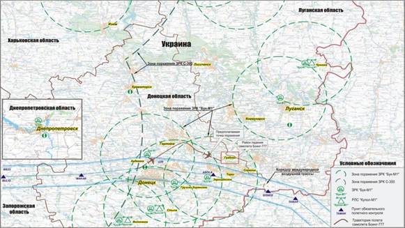
Figure 1 – Russian MoD map of Ukrainian BUK-M1 deployments in central Donbass on July 17, 2014
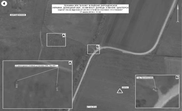
Figure 2 – Russian MoD satellite image of Ukrainian BUK-M1 vehicles deployed south of Zaroshchens’ke Village, Donetsk Oblast[8]
Two days after the Russian presentation, Marie Harf of the United States Department of State responded to the Russian MoD during a press conference by claiming that the disposition of Ukrainian BUK assets was different than shown by Russia, albeit without providing any alternative disposition of assets to the public[9].
During a question and answer period she stated:
MS. HARF: …
Russia … has also released a map with the alleged locations of Ukrainian
SA-11 units within range of the crash. This is another red herring they’ve put
out there. We are confident that this information is incorrect. The nearest
Ukrainian operational SA-11 unit is located well out of the range from both the
launch and the crash site. So part of their case yesterday was not only
giving more information about what we know, but giving our professional,
technical assessment of some of the Russian claims that, I think, we have tried
to increasingly knock down.
QUESTION: When you said – when they – when you said they showed evidence of this, what do you mean by that, “they showed”? They – I mean, did they have a presentation? I —
MS. HARF: Well, they – they did. They did. They showed some imagery, they showed a number of images; they showed some maps, they showed some graphics. I’m happy for you to get in touch with DNI Public Affairs, who can probably give you that packet that they showed. They showed some – one of the maps that we actually have posted on our Facebook page and our Kyiv Embassy that shows the trajectory of the SA-11 missile. That trajectory is based on classified information. I can’t detail all of what that information is, but that is based on the information we have. …
MS. HARF: So the Russians have basically had a couple of alternative explanations. … There was the Ukrainian fighter jet. I think we – the intelligence community went to great lengths yesterday to show why that’s not the case.
The other – one of the other things they said was that it was a Ukrainian SA-11 system that the Ukrainians had fired. Again, I think they made very clear why that’s not also the case. …
QUESTION: Right. But I mean, if you just look at that – a lay person looking at it, it’s a line drawn on a satellite photo with no – nothing to back it up.
MS. HARF: Well, as I said, it’s based on a series of classified information —
QUESTION: Which we have to … take the leap of faith to believe that – right?
MS. HARF: Well, Matt, we are trying to put as much … information out about this as possible. We are trying very hard to do so. It is a process that takes, I think, more time than any of us, certainly you or I, would like.
QUESTION: Right.
MS. HARF: But I think I would make the point that it’s much more time-consuming to declassify real evidence than to make it up, which is what the Russians have been doing for days now.
QUESTION: Okay. Well, be that as it may, are you saying that at some point, the IC is hopeful … that they will be able to put —
MS. HARF: We’re working to get more information declassified and put out there as quickly as we can. It’s just a difficult process (inaudible).
QUESTION: Okay. But do you understand that given the conflicting claims, no matter how ridiculous you say the other side’s version is and no matter how implausible it might be – but saying that you’ve put together the imagery showing the root of this —
MS. HARF: Trajectory.
QUESTION: — trajectory showing imagery.
MS. HARF: Just one piece. It’s one piece of evidence.
QUESTION: Well, I know, but anyone can draw a line on a map. They can. I mean, I’m not saying that —
MS. HARF: That’s not what our intelligence community does. That’s not what the U.S. Government does when we go out there and present a case to the world. … We have to protect sensitive sources and methods. We have to, because if we don’t, we won’t be able to get this kind of information in the future if they’re compromised because of a declassification. Believe me, I want to be able to declassify more.
QUESTION: Right, okay.
MS. HARF: They want to be able to declassify more. And it’s not about a leap of faith. We are laying out a very comprehensive argument based on a number of different pieces … look at the entire picture, it presents a very compelling case about the kind of missile, where it was fired from. Those are the two key pieces, right. The kind of missile that took down this plane we are very confident is an SA-11, we are very confident it was fired from Russian-controlled territory. We are very confident that the two alternate stories the Russians put forward aren’t
plausible.
Regarding these comments, three points must be noted. First, Ms. Harf claims: “The nearest Ukrainian operational SA-11 unit is located well out of the range from both the launch and the crash site.” It seems she is referring to the Ukrainian BUK battery and KUPOL unit at Styla. This location was the probable start location for the TELAR’s deployed to Gruzko-Zoryanske and Zaroshchens’ke. We note Ms. Harf refers to “the nearest Ukrainian operational SA-11 unit”. A complete BUK unit includes a Command
Post, TAR, TELAR(s) and TEL(s). However, Russia claimed detection of TELAR’s
deployed on their own at a distance to the main units and possibly acting independently
on July 17. It is not clear that American signals intelligence assets in theater could detect and specifically locate individual BUK TELAR’s operating autonomously at a significant distance from their Command Post and KUPOL.
Second, she claims the Office of the Director of National Intelligence “showed some imagery, they showed a number of images; they showed some maps, they showed some graphics. I’m happy for you to get in touch with DNI Public Affairs, who can probably give you that packet that they showed.” The AP’s Matthew Lee is very surprised to hear of this presentation, stammering: “When you said … they showed evidence of this, what do you mean by that, “they showed”? … [D]id they have a presentation?” Apparently it was not made to the press and it seems no one outside Fort Meade and Langley has seen this
evidence right up until today. The packet of information supposedly shown, other than the infamous Snizhne launch site Power Point graphic, has never been seen by the public or the press.
Third, she claims “The kind of missile that took down this plane we are very confident is an SA-11, we are very confident it was fired from Russian-controlled territory.” The phrase “Russian-controlled territory” is repeatedly used by American officials discussing MH17. At the time there was a lack of accurate maps of the actual battle front in the area of Shakhtersk-Torez-Snizhne. As seen in Figure 3 below, Zaroshchens’ke was shown deep within Militia controlled territory on maps released by the National Security and Defense Council of Ukraine. But so to was Ukraine’s rear operational bases around
Amvrosievka shown in Figures 4, 5, and 6. We will show Zaroshchens’ke was
actually directly adjacent to areas clearly under the control of the Ukrainian military.
It is unclear if the United States Department of State was aware of this fact, or if “Russian-control” means all areas not clearly occupied by the Ukrainian Armed Forces by default without consideration of the presence of the Militia. It is also not clear why Ukraine so misrepresented the situation on the ground. Perhaps they did not want to be seen holding any land anywhere near Zaroshchens’ke.
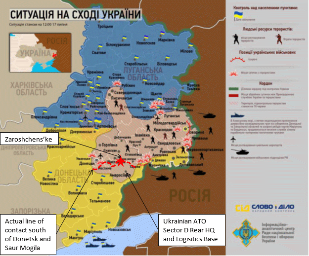
Figure 3 – Alleged military territorial control situation in the Donbass, July 17, 2014 according to the Ukrainian National Security and Defense Council[10]
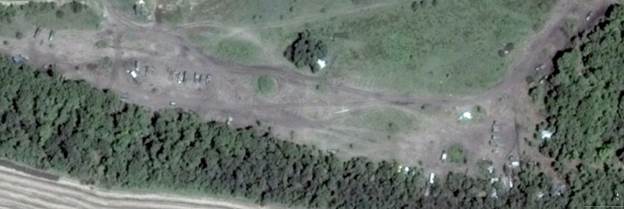
Figure 4 – Field Headquarters of Ukrainian Armed Forces ATO Sector D (47°44’34″N, 38°22’04″E) as seen on Google Earth July 16, 2014. Note numerous military vehicles and field tents.
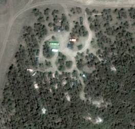
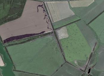
Figures 5 and 6 – From Google Earth July 16, 2014. Right: Field Camp of Private Military Contractors advising Ukrainin Armed Forces in ATO Sector D (47°44’20″N, 38°06’52″E). Left: 5 km2 Rear Logistics Base of Ukrainian Armed Forces in ATO Sector D. (47°45’46″N, 38°30’36″E)
Nine days after Russia’s barrage of data, questions, accusations, and reminders of past misconduct in shooting down civilian airliner Siberian Air 1812, Ukraine responded. On July 30, 2014, Ukraine’s SBU mounted a partial defense questioning the dates and content of Russia’s satellite pictures shown on July 21st by providing similar images obtained from American sources and pointing out what they claimed as key differences between the Russian and American imagery[11]. They claimed Russia had falsified, manipulated, and misdated pictures. Regarding Zaroshchens’ke, they claimed the images of their BUK-M1 TELAR’s were inserted into the image and that the base image was not from July 17. Unlike the US State Department they did not deny the veracity of the map of BUK deployments shown in Figure 1 or Russia’s figures regarding the number of BUK KUPOL radar installations emitting signals.
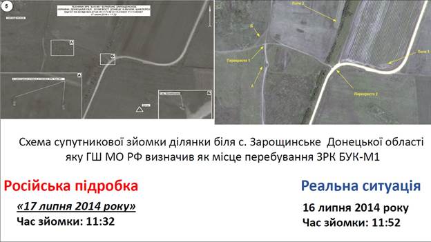
Figure 7 – Ukrainian image analysis claiming discrepancies between Russian and Digital Globe imagery
Concerning this image, SBU Chief Vitaly Naida Ukraine alleged:
The Russian generals disgrace themselves with another “satellite image, which depicts a diagram of a site near the village of Zaroshchens’ke, Donetsk region, which the General staff of the Defense Ministry have identified as the alleged location of SAM BUK-M1 (they are depicted in the larger square).”
“The weight of SAM BUK-M1 equipment fully loaded is more than 32 tons. On the Russian photos – both on the big and the small one – there are no signs of movement of BUK-M1 on fields sown with wheat, the tracks were neither on one side nor the other. On photos from a few days later these tracks still have not appeared,” he said.
In addition the Ukrainian harvest has helped expose the falsifications of the Russian General staff. The Russians, apparently, did not know that as of July 16-17, imagery shows the fields are already cut.
“The field which is located southeast of the intersection number 2 (marked on the images for July 16) – field #1 – is fully harvested. And this is the day before BUK’s
were allegedly here. On the Russian photo we see that the field is only partially
harvested, and this despite the fact that the photo they have is from July 17.
That is, the day before this field was harvested, and in the Russian photos it
is not yet harvested. The same symptoms we see in the upper part of the
inscription: the field #2 was harvested and there are clear traces of movement
of tractor machinery, but on the Russian photographs these traces are missing”
– said V. Naida.[12]
Most of these objections were answered by Russia through the publication the following day of an internet presentation “Analysis of satellite imagery released on the Internet by the Security Service of Ukraine on July 30, 2014.”[13] However one charge needs to be addressed separately. Ukraine alleges that the field with BUK’s was sown with wheat but that the BUK’s did not leave track marks in this field. In examining the progression of satellite images of this field on Google Earth and Terraserver, there is no sign that this field was ever planted or harvested in 2014 or 2015. Instead it appears the field was fallow and covered in relatively short grass. Despite the weight of the BUK-M1 TELAR, it is supported by two large wide crawler tracks that spread its weight over the ground with a pressure very similar to that of the feet of a large man – exerting less than 0.5 kg/cm2 in pressure. If the ground is dry and hard, which it would be in the middle of summer, and the grasses are short and hardy wild plants, there is no reason a single BUK vehicle needs to leave noticeable tracks on a 1 m resolution space image any more than a man or a car or truck leaves tracks if it runs over the yard of a house.
In the Russian MoD’s new presentation from July 31, they stood completely behind their previously presented pictures, including releasing a higher resolution version of the Zaroshchens’ke image, and accused the Americans and Ukrainians of falsification of their space imagery stating:
The Russian Defence Ministry has analyzed the satellite imagery released by the Security Service of Ukraine (SBU) on July 30, 2014, which allegedly disproves the authenticity of the Russian satellite imagery showing the BUK-M1 batteries in the Boeing 777 (MH17) crash site area on July 17 and confirms that Russian Armed Forces opened fire on Ukrainian territory.
First of all, one needs facts to level grave accusations or make conclusions. It is widely acknowledged that geo-reference and astronomical time are necessary for satellite images to count as factual evidence in order to pinpoint specific satellites in a constellation that was flying over the area at the time and take into consideration their technical characteristics and capacities. All satellites orbiting the Earth move in accordance with predetermined trajectories.
In connection to this, we can state that according to the Russian space surveillance system, Ukrainian satellites Sich-1 and Sich-2 were not flying over this territory from 10am to 1pm Moscow time (GMT+4; 9am-12pm GMT+3) on July 12, 16, 17 and 18, 2014.[14]
At the time specified in the images, the American electro-optical reconnaissance satellite of the Key Hole series was flying over the crash site area, so the source of the images for Ukrainian Security Service is obvious. …
The images on Slides 3 and 4 require a more detailed review.
Here the specified time does not correlate with the image.
Thus, these images were not only made on a different day, but also in the afternoon, which means the specified time has been deliberately falsified.
That is an indisputable fact. The images released by the Russian Defense Ministry on July 21 are absolutely accurate in terms of the location and time.
Moreover, it is clearly visible that in the SBU’s image the circled tree belt has been deliberately distorted. The Russian satellite image does not have these distortions. …
The resolution of the Russian satellite image on Slide 5 [showing Ukrainian BUK’s at Zaroshchens’ke] has been deliberately lowered, which resulted in the outlines of the terrain (i.e. field) looking smeared.
The Russian Defense Ministry presented a high-quality satellite image of this area (as follows), which has no alleged inconsistencies pointed out by the SBU.
In conclusion, based on the data provided by the Russian space surveillance, one may deduce that Ukraine does not own the disclosed information.
However, its quality, as well as the SBU’s arguments allegedly proving Russia’s involvement, are absolutely implausible.
Apparently, the reason why the true owners of these images have not put their names to these publications is to make sure the myth of their mighty space intelligence keeps going.
After this the Russian MoD’s questions about the shootdown of MH17 and Ukraine’s deployment of BUK-M1 units into the zone of military operations in the Donbass faded from view without answers. It seemed much of the world took a dim view of Russia’s efforts to exonerate herself and the DNR and LNR Militias. The Zaroshchens’ke deployment site of BUK-M1 TELAR’s in firing range of the final location of flight MH17 was seen as implausible and far-fetched. As previously noted the maps of the conflict situation on the ground saw this site as being in “control” of the DNR Militia. And while most of
the presentation and questions of the MOD had focused on the deployment of
Ukrainian BUK-M1 systems, the Russian press picked up and developed a narrative
of an aerial shootdown by a SU-25M1 ground attack fighter jet. This allowed
the Western and Ukrainian press and various internet researchers supporting the
Western narrative to oppose a Western scenario of a shootdown by a Russian BUK
missile vs. a supposed Russian narrative of a shootdown by Ukrainian air-to-air
missiles.
On May 5, 2015, a leaked document titled: “The Results of Peer Review of Investigation into Boeing-777 (flight MH17) Air Crash 17.7.2014 in the South-East of Ukraine”[15] was published by the Russian newspaper Novaya Gazeta. According to Novaya Gazeta, this document was clearly the work of engineers of the Russian Military-Industrial complex Almaz-Antey, the manufacturer of the BUK system.
Novaya Gazeta also emphasized at the conclusion of their reporting that the
front line in the area was not actually clear and everyone had access to the
area:
This report does not make the final word. Moreover, it creates new doubts and new questions. The main ones are: where Buk-M1 was launched from and who did it. That is not clear to understand, since there was no one front line at that time, and the map of battle operations resembled a layer cake with a number of so called
grey zones where everybody could drive in and return back with no problem. We
invite experts to take part in the discussion of the published report.
On June 2, 2015, the Ukrainian BUK debate sensationally came fully back to life when the Russian manufacturer of the BUK missile system, Almaz-Antey, gave a 90 minute press conference[16] and released a brief video[17] greatly expanding and expounding on the contents of the leaked report. These detailed their calculations as designers of the BUK system of (1) how the warhead of the missile was designed to work in ejecting its load of fragments to intercept and destroy targeted aircraft and (2) how this fragment cloud
would interact with a Boeing 777 flying along the path of MH17 if it had been launched
from the locations of Snizhne and Zaroshchens’ke in Donetsk Oblast.
Basing their conclusion on an extensive computerized reconstruction of the Boeing 777 and the fragment hole patterns on its wreck debris seen in photos, and on a dynamic computer model of the behavior of the missile and warhead, they were able to calculate the theoretical location of the warhead detonation near the plane, and the theoretical angle of attack of the missile in the horizontal and vertical planes within a few degrees of angle. The horizontal angle of attack gave a direction the missile flew from, and the vertical angle of attack gave a distance to the firing location along the direction of flight, since the missile approaches on an upwards slanting course when intercepting a relatively nearby target, such as hitting MH17 from Zaroshchens’ke, but “drops” down from above on more distant targets nearer its range limit, such as hitting MH17 from Snizhne, given the limitation of the
solid rocket propellant in its rocket engine. Based on these calculations, Almaz-Antey
found that if the MH17 had been shot down by a BUK M1 with a 9M38M1 missile, the
missile must have been fired from within a small approximately 9 square kilometer
area between Zaroshchens’ke and the nearby village of Shaposhnykovo. See Figures
8, 9, 10, 11 and 12. [18]
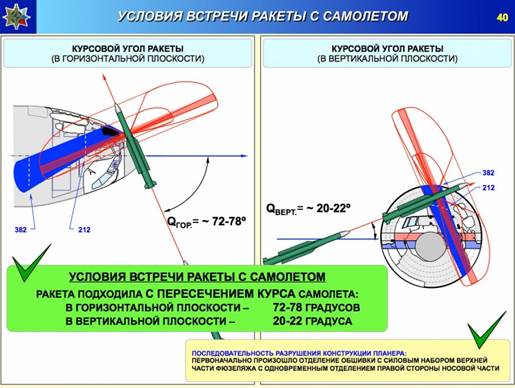
Figure 8 – Almaz-Antey slide demonstrating angle of attack of 9M38M1 missile based on damage seen on the plane wreckage and the lancet pattern of fragment emission of the warhead in motion.
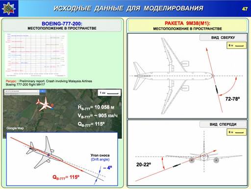
Figure 9 – Almaz-Antey slide summarizing flight angle of MH17 and angle of attack of 9M38M1 missile.
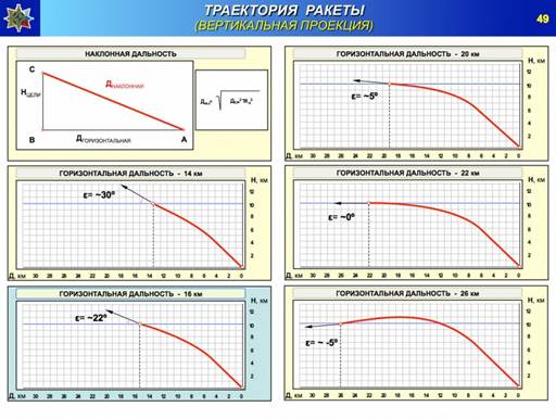
Figure 10 – Almaz-Antey slide summarizing effect of distance from launcher to target on the angle of attack of the 9M38M1 missile.
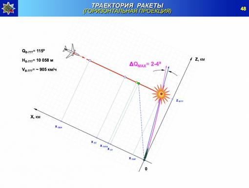
Figure 11 – Almaz-Antey slide showing slightly curved flight path of the 9M38M1 missile as it plots a course through the air to intercept its target
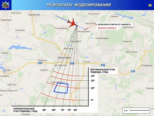
Figure 12 – Almaz-Antey slide showing projected launch area of 9M38M1 missile fired from a BUK-M1 launcher at MH17 based on damage seen on the plane and the flight characteristics of the missile.
With this comprehensive report, the long ignored issue of the deployment of BUK-M1 TELAR’s by Ukraine to the Donbass was back, and so were efforts to debunk the Zaroshchens’ke location. The most noteworthy response was a lengthy investigative paper published by the website Bellingcat on July 14, 2015[19],[20]
examining military field works and checkpoints discovered in the area around
Zaroshchens’ke using Google Earth imagery. Bellingcat also reviewed several maps purporting to show the military situation around July 17 and came to the conclusion that while the maps had certain inaccuracies, Zaroshchens’ke village and the surrounding area including Shaposhnykovo village and the adjacent town of Bolshaya Shyshovka was definitively occupied by the DNR Militia, and that if any BUK TELAR was located or fired from there, it had to have been done by the Militia with Russian Military backing because it was “conclusively” shown as an area in the control of the Militia.
On October 13, 2015, Almaz-Antey held a second press conference[21] and reported[22] on results of two live tests it carried out with BUK 9M38M1 missiles. In these tests they made a static detonation of the warhead into a target of aluminum sheet metal as if it were oriented coming from Zaroshchens’ke, and in a second test as if the missile had come from Snizhne, using the actual cockpit of an IL-86 airliner to provide a similar sized target to a Boeing 777.
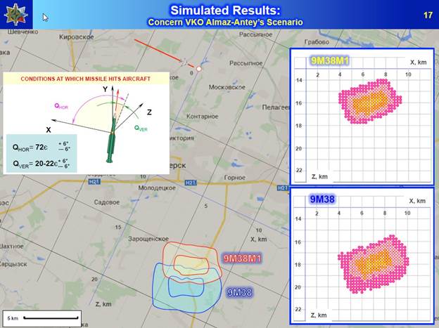
Figure 13 – Almaz-Antey slide showing revised projected launch area of missiles types 9M38 and 9M38M1 based on damage seen on MH17 and the flight characteristics of the missiles.
Based on the results of these live field tests and further refinement of the dispersal path of fragements in its computer model of the destruction of MH17, Almaz-Antey slightly revised their initial conclusions published in June. First, they extended their area of probable launch slightly southeast from Zaroshchens’ke towards the village of Mala Shyshovka as seen in Figure 13 as compared to Figure 12 above. See also Figure 14.
Second, based on the shrapnel pattern observed in their tests, where the “Butterfly” or “Bow-Tie” shaped shrapnel in the 9M38M1 missile produced numerous distinctive shrapnel holes not found in the actual aircraft skin of MH17, Almaz-Antey suggested that the missile used to shootdown MH17 was most likely the older 9M38M missile which contained only diamond shaped fragments. This missile was stated to have been retired from Russian military inventories in 2011 with the retirement of the BUK-M and BUK-M1 systems when the missiles reached the end of their design life of 25 years. On the other
hand, Almaz-Antey noted that Ukraine had previously been in possession of 502 of these types of missiles and had instead of retiring them, undertaken a program to rehabilitate the launchers and missiles and extend their life. This program has been undertaken by the company Ukrboronprom.[23] The first deliveries to the Ukrainian Armed Forces of rehabilitated BUK-M1 TELAR’s were in fact just occurring in June, 2014[24] to undergo operational testing.[25]
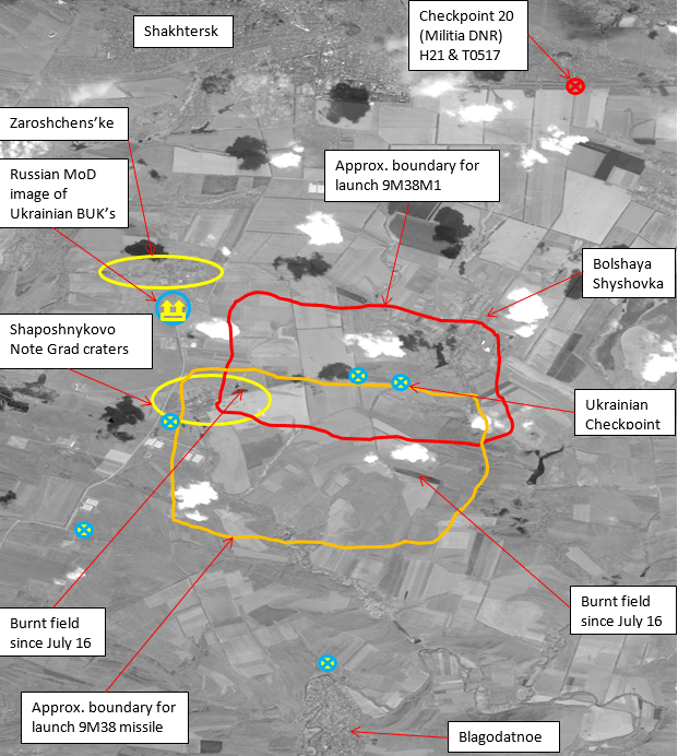
Figure 14 – Launch areas proposed by Almaz-Antey in October 13, 2015 presentation superimposed on satellite background imagery. Digital Globe Preview Photo 1020010031316300 – July 23, 2014
Evidence for the Operational Field Deployment of Ukrainian BUK-M1 Systems On and Before July 17, 2014 as Part of the Ukrainian Anti-Terrorist Operation (ATO)
The 156th Air Defense Regiment of the Armed Forces of Ukraine is a military unit equipped with BUK missile launchers. This unit had a headquarters at base A-1402 just south of Donetsk Airport, and three Battalion bases – A-1428 west of Spartak near Donetsk, A-0194 northwest of Lugansk, and A-1659 west of Mariupol. Each base was supplied with six BUK TELAR missile launchers, three BUK TEL launcher/reloader units, a single BUK
TAR KUPOL radar vehicle, and a BUK mobile Command Post. The bases also had two
low-loader haulers, a missile lift crane, missile transport trucks, fuel tankers, and a variety of military trucks providing other support functions. This regiment’s main BUK system equipment is numerically identified as seen in the table below.
|
Base ID |
Command Post (CP) |
Target Acquisition Radar (TAR) |
Battery |
Transporter Erector Launcher And Radar (TELAR) |
Transporter Erector Launcher (TEL) |
|
A-1428 Avdeevka (Donetsk) |
100 |
101 |
1 |
111, 112 |
113 |
|
2 |
121, 122 |
123 |
|||
|
3 |
131, 132 |
133 |
|||
|
A-1659 Berdyanske (Mariupol) |
200 |
201 |
1 |
211, 212 |
213 |
|
2 |
221, 222 |
223 |
|||
|
3 |
231, 232 |
233 |
|||
|
A-0194 Metalist (Lugansk) |
300 |
301 |
1 |
311, 312 |
313 |
|
2 |
321, 322 |
323 |
|||
|
3 |
331, 332 |
333 |
During the Crimean revolt in February and March of 2014, Ukraine lost control of its air-defense assets on the peninsula to the new Crimean Republic[26] and then the Russian military when Crimea declared independence and subsequently was annexed to Russia. This included the 55th Air Defense Regiment’s BUK-M1 vehicles, missiles, and personnel at Yevpatoria. When large anti-government protests in eastern Ukraine began in March of 2014 following the Crimean revolt, the Ukrainian Ministry of Defense took precautionary measures to move many of its remaining high value military air defense assets out of the Donetsk, Mariupol, and Lugansk urban areas to safer rear areas more firmly under the control of the new Ukrainian Government. This evacuation involved many, but not all, BUK-M1 TELAR’s, TEL’s, TAR’s, and Command Posts from bases A-0194, A-1428, and A-1659.
From base A-0194, BUK-M1 TELAR’s 311, 312, 321, 331, and 332, TEL 323, and TAR 301 were filmed being relocated mostly under their own power to Kramatorsk Airfield and then west towards Dnipropetrovsk in early and mid-March. Different parts of this movement were filmed twice in Soledar on March 5 (BUK’s 331 and 332 and then BUK’s 301, 312, 321, 323, 331, and 332)[27], on the M04 Motorway on March 16 at 15:36 pm (BUK’s 311 and 323)[28], in Yasynuvata on March 17 (BUK 312)[29] and March 19 (BUK’s 321 and 332)[30], and in Karlivka on March 19 at 9:47 am (BUK’s 312, 321, 332)[31]. Left behind at the base were BUK TELAR 322, and TEL’s 313 and 333 along with the two military low-loader tractor trailers assigned to the base. Possibly BUK Command Post 300 was also left, as it is not seen in the videos and pictures and a vehicle that could be this unit can be seen in some of the satellite imagery.
This is the most well documented movement. A member of the 3rd Battalion from Lugansk later stated in an interview with Anatoly Shary[32] that the unit had relocated to Vasyl’kivka in Dnipropetrovsak Oblast. In early July with the fall of Slavyansk, this unit was relocated again to Kramatorsk Airfield[33] and assigned air defense sovereignty tasks in Sector’s A and C of the ATO which covered all of northern Lugansk Oblast and northern Donetsk Oblast above the west side of the Gorlivka. Due to the size of the area assigned, an additional Ukrainian BUK unit was brought from central or western Ukraine to the ATO zone via Kharkov in early July to assist with this task. It seems extremely unlikely any BUK vehicles from the 3rd battalion were ever deployed anywhere in ATO Sector D south of Donetsk and Shakhtersk.
Figure 15 – Typical arrangement of Ukrainian BUK-M1 air defense assets at base A-0194 in Lugansk on Google Earth on February 25, 2014 (image rotated 90 degrees counterclockwise from north)
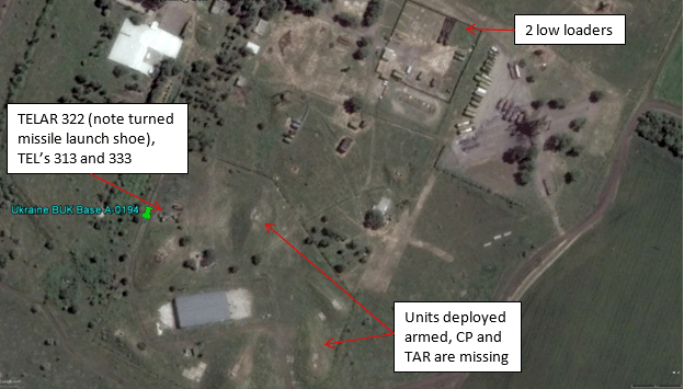
Figure 16 – Ukrainian BUK-M1 air defense assets at base A-0194 in Lugansk on Google Earth on June 5, 2014. CP 300, TAR 301, five TELAR’s and one TEL have deployed off base. TELAR 322, TEL’s 313 and 333 are left in semi-active deployment on base (image rotated 90 degrees counterclockwise from north)
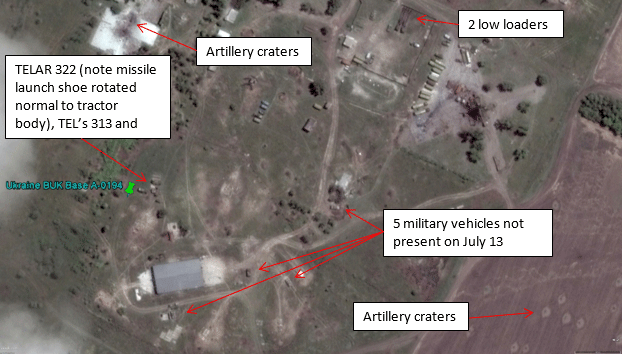
Figure 17 – Ukrainian BUK-M1 air defense assets at base A-0194 in Lugansk on Google Earth on July 16, 2014. TELAR 322 has moved and new military vehicles have appeared (image rotated 90 degrees counterclockwise from north)
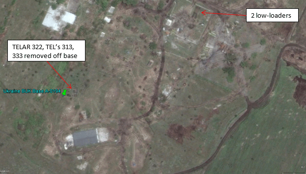
Figure 18 – Base A-0194 in Lugansk on Google Earth on August 8, 2014, note additional artillery craters. All BUK’s removed from base no later than July 27, 2014 (image rotated 90 degrees counterclockwise from north)
The late removal date of July 28 is demonstrated by imagery at Terraserver. [34] It is not clear who removed these three BUK vehicles.
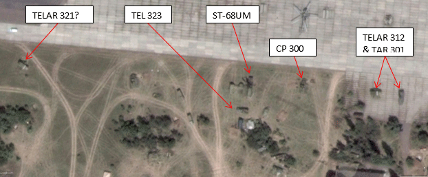
Figure 19 – Kramatorsk Airfield on Google Earth on July 23, 2014. BUK’s are identified based on ground photos taken of vehicles on the base. TELAR 311 is likely elsewhere on base and appears on the July 26 image just to the left of this image, while TELAR’s 331 and 332 are off-base. An ST-68UM “Tin Shield” radar is also present and operational, just like at base A-0194 before the war.
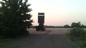
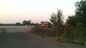
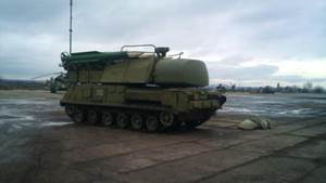
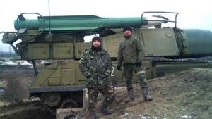
Figure 20 – Ukrainian BUK TAR 301 and TELAR 312 at Kramatorsk Airfield in July 2014 (top) and in the winter of 2015 (bottom).
From Base A-1428 BUK-M1 TELAR’s 121 and 122 were moved military low-loaders on the M04 highway through Karlivka and Krasnoarmieysk towards Dnipropetrovsk on March 12, 2014[35]. A conscript soldier of the regiment told a member of the Ukrainian press from Orbit[36] that they were informed this was to perform training exercises off base[37].
BUK CP 100 and TAR 101 were also removed around this time, as were two other TELAR’s and one TEL. TELAR 132 and TEL 123 were left behind apparently along
with one other TELAR and one other TEL whose numbers are not known at this time.
These units were clearly active into the summer as they shift positions on the base and their missile launch shoes are rotated. The units of Battalion 1 deployed off base also went to Vasyl’kivka in Dnipropetrovsak Oblast with Battalion 3 from Lugansk. The portion of this unit deployed off base returned to Donbass in July and was assigned to Sector B of the ATO which covered western Donetsk Oblast between Dokuchajevsk and Gorlivka. The BUK assets left at this base remained at or near the base during the Ukrainian ATO operation through the conquest of the Donetsk Airport by the DNR Militia. During the
battle for the airport in late summer and fall of 2014, TELAR 132 and TEL 123 were damaged by shelling and eventually all four BUK units were destroyed in the final battle in the winter of 2015[38]. On July 17th, TAR 101 would likely have been the KUPOL radar unit detected at either Volnovakha or Styla.
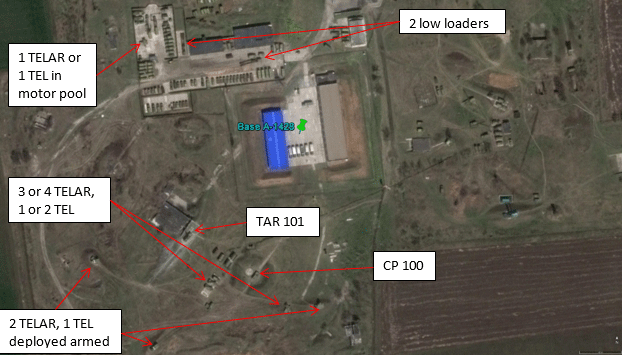
Figure 21 – Typical arrangement of Ukrainian BUK-M1 air defense assets at base A-1428 in Donetsk on Google Earth on April 17, 2012.
Figure 22 – Ukrainian BUK-M1 air defense assets at base A-1428 in Donetsk on Google Earth on April 28, 2014. Remaining BUK units still active as indicated by presence of low-loader transporter.
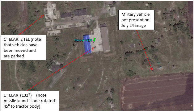
Figure 23 – Ukrainian BUK-M1 air defense assets at base A-1428 in Donetsk, as on Google Earth on July 27, 2014. All BUK units on base appear to have been operated during past three months.
We have not yet found an internet record of the movement of BUK-M1 assets out of Mariupol, but it appears 6 or 7 of the BUK’s stationed there definitely left the base in March, 2014 along with the two low-loaders, as they disappear from Google Earth satellite imagery by March 30, 2014. This included BUK CP and TAR 200 and 201. Left behind at the base were two BUK TELAR’s and two or possibly three BUK TEL’s. Battalion 2 of the 156th Regiment was assigned to Sector D of the ATO. This base remained safely in Ukrainian hands throughout the conflict and by September 5, 2014, Ukraine had relocated all of the BUK units from this base to other locations. On July 17th, TAR 201 would have been the KUPOL radar unit detected at either Volnovakha or Styla.
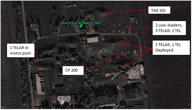
Figure 24 – Typical arrangement of Ukrainian BUK-M1 air defense assets at base A-1659 in Mariupol on Google Earth on October 8, 2013.
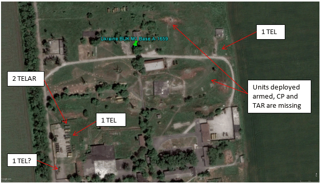
Figure 25 – Ukrainian BUK-M1 air defense assets at base A-1659 in Mariupol on Google Earth on May 30, 2014. CP 200, TAR 201, four TELAR’s and possibly one TEL have been deployed off base.[39]
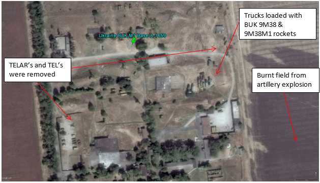
Figure 26 – Base A-1659 in Mariupol on Google Earth on September 5, 2014. All BUK-M1 units have been removed from the base. Trucks loaded with BUK 9M38 and 9M38M1 rockets in transport cases are sitting in front of the munitions storage area. These are likely being removed ahead of the ongoing attack by the DNR Militia on Mariupol.
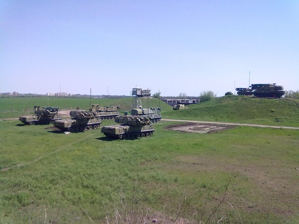
Figure 27 – Typical arrangement of BUK M1 units at Base A-1659 in Mariupol prior to March 2014. Picture taken from normal deployment location of TAR 201. One battery is armed and actively deployed on the mounds consisting of two TELAR’s (on the right) and one TEL (on the left). The BUK launchers of the other two batteries are parked in the foreground. One BUK TELAR is missing and is likely in the motor pool area undergoing running repairs.[40]
This overview of the deployment of the 156th Regiment’s BUK’s off base allow us to state with confidence that if Ukrainian BUK’s were deployed to Zaroshchens’ke on July 17th, they would have come from either the first or second battalions.
On June 4, the Militia of the LNR attacked base A-0194 and destroyed the radar installation on site and damaged or destroyed several military vehicles. A similar attack on radar facilities was carried out on June 21 at base A-1428[41]. On June 29, the Militia of the DNR captured base A-1402 and issued a press release regarding this action[42].
This brief message was extended in the Russian press to include imaginative information claiming seizure of BUK missile systems that would soon be protecting the skies of the rebel Republics. In response, the Ukrainian Ministry of Defense felt compelled to issue a statement[43] denying the loss of any working BUK systems to the rebels. Instead they
surprisingly stated (given the lack of Militia air warfare capabilities) the systems were in use on combat duty:
Усі бойові машини військових частин протиповітряної оборони Збройних Сил
України перебувають у визначених районах і несуть бойове чергування
по захисту повітряного суверенітету держави. – All military combat vehicles of air defense units of the Armed Forces of Ukraine are in specific areas and are on combat duty to protect the air sovereignty of the state. [44]
This quickly became evident to the world. Photographer Dmitry Lovetsky of the Associated Press captured BUK –M1 TELAR 321 northwest of Slavyansk on July 4, 2014 near Izyum, which was then functioning as the general field headquarters of the ATO.[45]
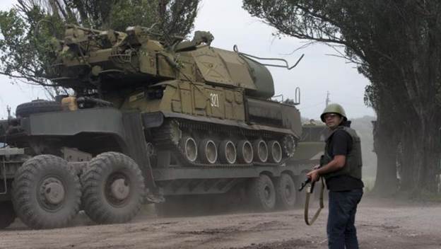
Figure 28 – Ukrainian Armed Forces BUK-M1 TELAR 321 northwest of Slavyansk on July 4, 2014.
On July 5th, Ukrainian television broadcast images of a BUK-M1 TELAR 332 and TEL 323 and an additional TELAR (probably 331) from the Lugansk Battalion of the 156th Air Defense Regiment deployed on active combat duty in the ATO Zone.[46] See Figure 29 below.
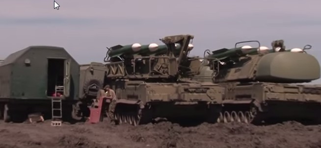
Figure 29 – Ukrainian Armed Forces BUK-M1 TEL 323, TELAR 332 and undetermined TELAR (to rear of first TELAR) in active deployment in the Donbass in the zone of the ATO (location undertermined)
On July 12th, Ukraine ATO Spokesman Vladyslav Selezniov further stated[47]:
Regular air defense of Ukraine was put on readiness alert No 1 in order to reduce
response time to possible threats of shelling from the direction of the state
border with the Russian Federation by multiple rocket launch systems BM-21
“Grad” of stronghold units of the Armed Forces of Ukraine, which take part in the anti-terrorist operation in the Donetsk and Luhansk regions.
On July 16th, images of a STRELA-10 launcher, two Ukrainian BUK-M1 TELAR’s, a BUK TAR KUPOL radar, and an ST-68UM Tin Shield radar trailer on active combat duty in the ATO zone were broadcast on Ukrainian TV[48]. The show depicts 6 seconds of BUK-M1 equipment in two separate locations. See Figures 30 and 31 below. To date, we are not aware of any attempt to geolocate these images despite the obvious relevance to the MH17 investigation of accurate information concerning the deployment by the government of Ukraine of the weapon type alleged to have brought down Malaysian Flight MH17.
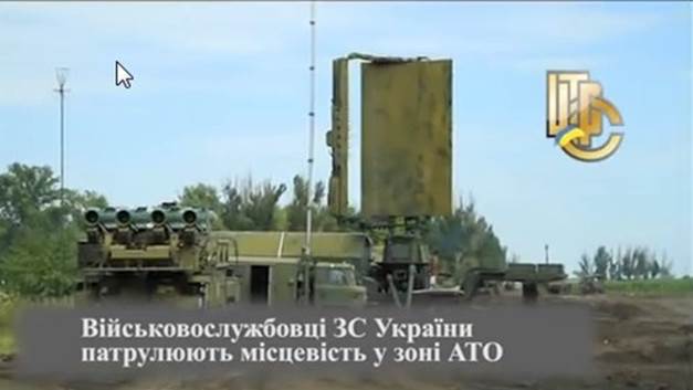
Figure 30 – Ukrainian Armed Forces BUK-M1 TELAR, ST-68UM “Tin Shield” Radar, and Mobile Command Post in active deployment in the Donbass in the zone of the ATO (location undetermined)
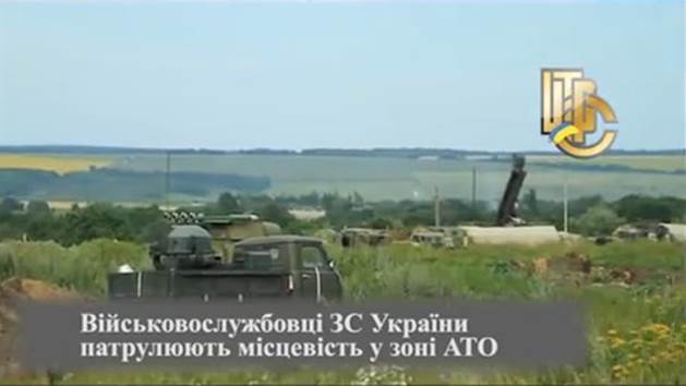
Figure 31 – Ukrainian Armed Forces BUK-M1 TELAR and TAR/KUPOL radar in active deployment in the Donbass in the zone of the ATO (location undetermined)
It is fair to ask, as the Russian MoD did, why these systems are deployed to the Donbass when the Militia lacked airpower. One possibility is the claim of the Ukrainian Military Headquarters General Staff that their forces under attack by Russian military aircraft. One example of these claims comes from July 16 where it was stated that a Ukrainian
SU-25M1 was shot down by a Russian MIG-29.[49]
A Ukrainian airplane Su-25 was shot down by the Russian airplane on July 16th, said the speaker of the council for the national security and defense of Ukraine, Andrey Lysenko.
“On July 16th at about 19:00 yet another provocation was carried out from the Russian side. The military airplane of the armed forces of the Russian Federation carried out a missile strike against the Su-25 airplane of the Armed Forces of Ukraine, which was performing missions on the Ukrainian territory. Our airplane was shot down. The pilot catapulted and was evacuated into safety by the AFU detachments. The pilot is OK,” – said Lysenko.
While the Russian MoD denied its involvement and placed responsibility for the shootdown on the Militia, who also boldy claimed responsibility for the shootdown, belief or pretense by Ukraine that Russia was involved would be a reason to implement its standing border airspace denial strategy using its BUK Air Defense Regiments. In Donbass, this meant active deployment of the 156th Regiment into positions along the state border to protection Ukraine’s air sovereignty and its troops deployed north of Lugansk and south of Donetsk, but without needlessly and provocatively overlapping target radar coverage into Russian air space, which Russia might view as aggression against its own air space.
Returning to the Russian MoD map in Figure 1, we in fact see just such a posture in the alleged Ukrainian deployment plan of July 17th, with BUK batteries spaced apart in an overlapping pattern to protect as much of the border as possible from a distance roughly 35 km back from the border to avoid overlapping into Russia other than just north of Lugansk. From this vantage the units could engage in air-space denial in areas of active conflict in the south around Mospyne, Amvrosievka and Saur Mogila, and in the north around Lugansk Airport and Metalist by painting any Russian aircraft detected with
targeting radar and threatening to launch.
The story of Ukraine’s BUK deployment in mid-July during its “ATO” takes one final strange turn on July 17. Having just proudly broadcast on the evening of July 16 images of BUK launchers active in the field, perhaps in reaction to the ITAR-TASS story cited above, Ukraine turned around four and a half hours after the crash of MH17 and denied having not only BUK-M1 deployed in the field, but even the less potent STRELA-10 system.[50]
A high-ranking source for “censor.net” in operational command “South” commented on the circumstances of the destruction of the Malaysian “Boeing” near Torez:
“On July 17 Ukrainian aircraft did not undertake flights over the territory of the
Luhansk and Donetsk regions. Ukraine can easily prove the complete absence of
our aircraft in the sky – the last flight was the evening of July 16 – the day before the tragedy with the Boeing. The nearest positions of Ukrainian troops are at a distance of 50 kilometers from the crash site of the airliner – we do not control the territory over which was destroyed by Boeing. We do not have long range air defenses in operation in the zone of the ATO, our units are provided exclusively military air defence systems “Shilka”[51]and “Tunguska”[52],
which can hit targets only up the height of 5 kilometers. Thus, it is possible
to state with all responsibility – Ukraine is absolutely not involved in the
destruction of the “Boeing”, and it will be easy to prove it. The aircraft was destroyed by a Russian air defense missile system “Buk”, manned by Russian military specialists. On July 14 and 16 near the route on which the Malaysian plane was flying, flew a Ukrainian transport aircraft Il-76, but they operated at lower
altitudes of 6 to 7 thousand meters. Obviously the Russian specialists have
confused the “Boeing” with our transport, and did not pay attention to altitude[53] and the fact that the liner flies on an international air corridor. Undoubtedly, any international Commission will quickly establish all the circumstances that confirm this version, and will permit the exposure of this act of international terrorism perpetrated by Russia.”
The statement included regarding 50 km separation is true regarding the areas west, north and east of the crash site, but not to the south. There Ukraine had over 5,000 troops troops around Dyakove, Saur Mogila, Amvrosievka and the region to the north, south of Ilovaisk and around Mospino, something one would expect “a high-ranking source … in operational command ‘South’” to be very much aware of.
There is a final coda to this off-base deployment that perhaps provides an unintentional clue as to which Ukrainian BUK’s were sent to Zaroshchenske on July 17. On July 18 Tweets began to appear that mentioned BUK’s near the area of Amvrosievka, an area that the Russian MoD had yet to mention as a Ukrainian BUK deployment location. Any BUK’s deployed by the Ukrainian military to Zaroshchens’ke would need to transit Amvrosievka to reach where they were photographed by the Russian satellite.
July 18 – Twitter @Makovenko_A, July 18, 2014, 10:18 am[54]
Где след от ракеты Бук? Желательно в районе Амвросиевки, где есть небоеспособные Буки ДНР. – Where is the trail from the BUK missile? Hopefully in the area of Amvrosievka, where there are combat disabled DNR BUK’s.
The person tweeting seems aware of BUK’s in Amvrosievka and mistakenly attributes them to the DNR perhaps following the incorrect military situation maps provided by the Ukrianian NSDC.
July 20 – Twitter @Ed_Abrossimov, July 20, 2014 18:27 pm[55], 18:30 pm[56], 18:31 pm[57] (mocking the tweets and summary[58] of the US Embassy in Russia outlining the American version of events on July 17)
Во время потери контакта с рейсом #MH17 зафиксировали пуск ракеты
“земля-воздух” из посёлка, контролируемого укронаци. – At the time of the
loss of contact with flight #MH17 the launch of a SAM rocket was recorded from the settlement controlled by Ukronazis.
Посты в соц.медиа от 17.07 говорят о передвижениях средств ПВО SA-11
в контролируемой укронацистами Амвросивеке – Posts in social media from 17.07 report about the movement of an SA-11 Air Defense system under the control of a Ukronazi unit near Amvrosievka.
Из Амвросиевки SA-11/”Бук” обладает возможностями диапазона и высоты для того, чтобы укронацисты сбили борт – From Amvrosievka,
the SA-11/”BUK” has the capability in range and height in order for the
Ukronazis to shoot down the airplane.
Then there is a mysterious Twitter account that has been inactive since the end of August, 2014 that never replied to anyone or reposted anything and that appears to be one side of a hidden conversation or stream of information. This account also made a statement about BUK’s in Amvrosievka, commenting on some information we are not privy to:
July 22 –Twitter – @bubzlette, July 22, 2014, 5:06 am[59]
Если это один и тот же бук то получается он перемещался совсем не от
амвросиевки. – If it is one and the same BUK it turns out he did not roam from Amvrosievka.
Finally there is a post that provides us with a real clue:
July 26 – Twitter – @tombreadley, July 26, 2014, 21:26 pm[60], @PrkyrorCrimea, July 26, 2014, 21:30 pm[61], @tombreadley, July 26, 2014, 21:36 pm[62]
Помните ебанашку с в/ч ПВО с Амвросиевки, там где фотки с Буками
были… Гусь собрался судиться – Remember the nutjob with the Air Defense military unit in Amvrosievka, where the pictures with BUK’s were… the goose is going to sue
А че они про него написали ?Это же вроде наш срочник. – What they wrote about him? It seems like our conscript.
Да – Yes
This last set of posts refers to the photo below in Figure 32, which shows Ukrainian
military conscript Sergey Paschenko guarding an obviously combat active BUK
unit supposedly near Amvrosievka including BUK TELAR 121.
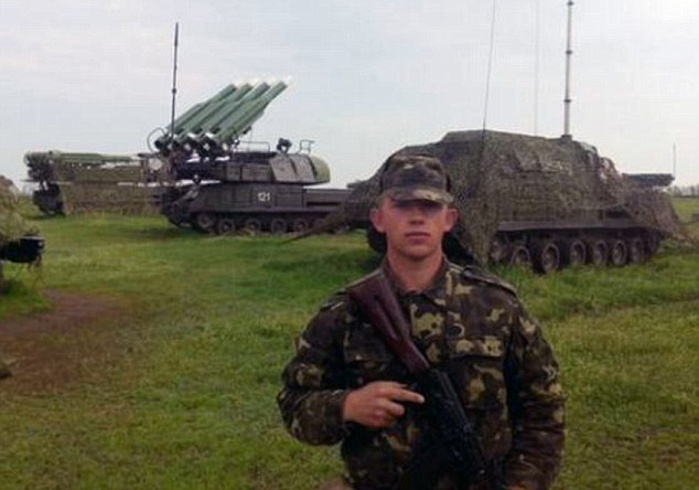
Figure 32 – Sergey Paschenko standing guard in front of several BUK units deployed away from base A-1428 into the field, supposedly near Amvrosievka
This photo had been taken from his VKontakte wall (it is now deleted)and used by the English newspaper The Daily Mail on July 22, 2014 in a bizarre and misguided propaganda broadside using the satellite imagery of the Russian MoD (!) to brand him a Russian terrorist guarding the BUK that shot down MH17.[63] It was left to Russia Today to clarify that he was in fact a Ukrainian Army conscript.[64] The BUK TELAR in the picture is BUK 121 from base A-1428 in Spartak, northwest of Donetsk. The other vehicles in the picture are a BUK Command Post in the foreground and a BUK TEL in the background. It is likely these are Command Post 100 and BUK TEL 113 or 133. However if the picture is truly taken in Amvrosievka, and the Ukrainian partisans who tweeted about seemed quite certain of that fact, then it is very probable that BUK TELAR 121 and its sister TELAR 122 are the two TELAR’s on Russia’s satellite image of Zaroshchenske from July 17, 2014. Perhaps the Daily Mail and the pro-Ukrainians have accidentally led us to the unit which fired on MH17.
If MH17 was downed by a BUK missile fired from near Zaroshchens’ke, as suggested by the Russian MoD and more strongly asserted by Alamaz-Antey, this picture makes it appear the commanding officer of the second battery of the first battalion of the 156th Air Defense Regiment is a person who needs to explain where he and his unit and equipment was on July 17, 2014.
Military Situation Reports, News Reports, and Social Media Postings Concerning Control in the Area of Bolshaya Shyshovka[65], Shaposhnykovo and Blagodatnoe[66] Compared with Google Earth Imagery
A search was made for references to military operations in the region inside the H21 highway on the north, Saur Mogila on the east, Ilovaisk on the west in daily after-action reports of military operations put out by both sides in the Donbass Conflict and on Twitter and VKontakte. Where numerous reports providing the same information appear, we have tried to select the earliest report and to consistently sample reports from the same local sources.
There is relative dearth of references to this area in comparison to other more contested areas with daily battles. The reports generally speak of groups of the Ukrainian Armed Forces occupying or moving north from this region and that the Ukrainian military units in the area collectively form a large group. In discussing the Militia, the sources generally say they are shelling this area or conducting a raid into it and are present only on its
outskirts.
Reports Prior to July 7, 2014
During this period there are just a couple of references to an event in Blagodatnoe.
June 19 – Rusvesna.su – Bridge In the Village of Blagodatnoe in the Donetsk Republic Blown Up.[67]
In the Donetsk Republic on June 18 around 15:30 the bridge was blown up on the road T0517 Yenakiieve-Shakhtersk-Amvrosievka at the entrance to the village of Blagodatnoe in Amvrosievka district.
The explosion damaged the road surface of the bridge, destroyed three of the five beams of the superstructure and an intermediate support. Due to the incident, the Department of Highways in the Donetsk region the decided to close the bridge to traffic.
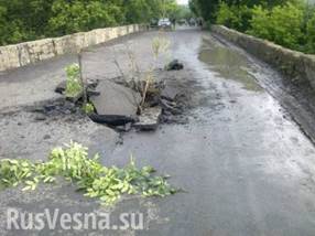
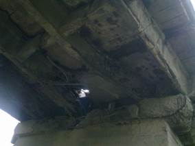
Figures 33 and 34 – The Road and Superstructure of the Krynka River Bridge in Blagodatnoe
June 19 – Novosti Donbass – Terrorists Damaged the Bridge of the Krynka River in the settlement of Blahodatne[68]
Today, as alleged by the residents of Blahodatne, the DNR Militia tried to blow up the bridge of the Krynka River on to the road to Shakhtersk and Torez. The newspaper “Donbass” reports about this.
According to local residents, the people trying to mine the bridge were not part of the Ukrainian Army or National Guard, who are located in the district center.
From these two reports, it is obvious the DNR Milita blew up the bridge north of Blagodatnoe. At this time this was the northernmost outpost of the Ukrainian Armed Forces in Sector D of the ATO. By damaging the bridge, the ground route to Shakhtersk and Torez was effectively severed, forcing the use of field roads to the east and west of the town to access settlements to the north. It is likely the Militia felt this was an effective
way of containing the Ukrainian forces from expanding northwards as the loss of this bridge combined with the natural barrier of the Donetsk Escarpment seemingly prevented any easy movement north by heavy Ukrainian forces.
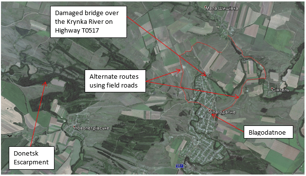
Figure 35 – Satellite Image Map of Area of Blagodatnoe
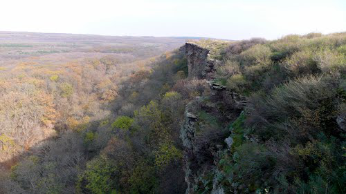
Figure 36 –The natural barrier of the Donetsk Escarpment (looking east), as seen in Google Panaramio
At the end of June the military situation between Amvrosievka and Shakhtersk is depicted in Figure 37.
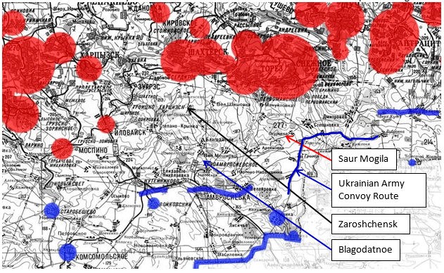
Figure 37 – Military Situation Map on June 28, 2014 in the center of ATO Sector D[69]
This map is a selection of a larger map available at the reference. In this map, the circles represent the relative population size of the settlements. The red indicates some sort of occupation by the Militia, and blue by the Ukrianian Army and Government. Along the Russian-Ukrainian state border, a blue line indicates the border is open and under control the Ukraine. The area with no line along the southern border is a closed border with an active military operation. In the interior of the map blue lines indicate areas of active offensive military operations.
In our particular area of interest, the DNR held sway over the cities between Donetsk and Snizhne on the H21 Highway. The towns of Ilovaisk and Mospino were only under DNR administrative control. As we shall see, they were not yet occupied by the DNR militarily. The Ukrainian Armed Forces held the Upenska crossing, Amvrosievka, and the area to the west and south. To the east, Ukraine was conducting an active military operation along the southern border east past Saur Mogila, which was held by the DNR Vostok Battalion. From this height, the Militia shelled the Ukrainian military convoys passing west to east to supply the border offensive. Zaroshchenske as located in the middle-north of a large neutral area not yet occupied by either party to the conflict. And the northernmost Ukrainian military outpost was in Blagodatnoe.
The Ukrainian forces in this area numbered over 10,000 and included the 3rd Spetsnasz Battalion, the 24th and 51st Mechanized Brigades, and the 79th and 95th Airborne Brigades as well as a number of National Guard units tasked with manning roadblock checkpoints. The area of active conflict was very limited due to the low number of troops available to the Militia. It consisted of artillery shelling from the height of Saur Mogila, raids south from Donetsk and Shakhtersk on convoys and checkpoints, and attacks on the spearhead of the Ukrainian attack to slow its advance along the border.
Meanwhile, the local populace deplored the loss of a peaceful life.
July 6 – Twitter @graff25 – July 6, 2014, 16:55 pm
Пока не приехало благодатное АТО небыло ни одного взрыва. – Until the ATO came to Blagodatnoe there was never a single explosion.
Reports from July 7 to July 18, 2014 – The First Battle for Ilovaisk and the Battle for Bolshaya Shyshovka
Overnight on July 5th, 2014, the Slavyansk Brigade of the DNR Militia commanded by Colonel Igor “Strelkov” Girkin made a strategic retreat from the cities of Slavyansk, Kramatorsk, Konstyaninovka, and Artemovisk. The forces removed from this sector were over 2,000 men and were organized in the equivalent of three 2/3rds strength battalion tactical groups and a Spetsnasz shock assault group.
These forces retreated to Donetsk and were given leave for two days of rest. On July 7th, the purpose of the retreat became apparent, as the Slavyansk forces began to undertake a new deployment south and east of Donetsk which would add tremendously to the pressure on the Ukrainian offensive in Sector D by increasing the area of battle contact. This first sign of this new offensive plan of the Milita came with the occupation of Ilovaisk and the northeast side of Mospino, which put them in position to begin harassing the rear supply lines of the Ukrainian offensive along the border.
July 7 – Twitter @KoraGray – July 7, 2014, 10:22 am[70]
Да, в Иловайск заехали террористы и, видимо, будут там обустраиваться
– Yes, in Ilovaisk the terrorists arrived and apparently will be there to stay
July 7 – Twitter @poggy_95 – July 7, 2014, 12:54 pm[71]
Новость дня : ДНРовцы в Моспино – News of the day: DNR “Army” in Mospino.
July 7 – RBC – Donetsk Regional State Administration – The Militia Began the Blockade of Ilovaisk Southeast of Donetsk[72]
A group of the self-proclaimed Militia Donetsk National Republic (DNR) began the blockade of the town of Ilovaisk reports the press-service of the authorities appointed by Kiev to the Donetsk Regional State Administration. Ilovaisk is located approximately 15 km southeast of Donetsk and is crossed by the railway line running to the Russian border.
July 8 – Twitter @Spaspb – July 8, 2014, 6:05 am[73]
От РУШІЙНА СИЛА ДОНБАСУ Вчера в 23:24 #Донецк Поступила
информация, что в город Моспино зашёл отряд боевиков численностью
до 100 человек. – From DRIVING FORCE of DONBASS yesterday at 23:24 pm #Donetsk Information received that a squad of militants numbering up to 100 people came to the town of Mospino.
July 9 – Twitter @Antikolorad – July 9, 2014, 14:23 pm[74]
#Иловайск: 150 на камазах, остановились в пионерском лагере “звездочка”,
это в поселке Покровка сегодня приехала в город. поставили блокпО – #Ilovaisk: 150 in KAMAZ’s, who were staying in the Pioneer Camp “Zvezdochka” in the settlement of Pokrovka, arrived today in the city to put in a blockpost.
This deployment could not help but provoke a reaction from Ukraine, which was not long in coming.
July 11 – Russia Today – Ukrainian Forces Are Trying to Take the Town of Ilovaisk[75]
In the vicinity of Donetsk there is a battle between the Ukrainian security forces and troops of the unrecognized Donetsk National Republic, a source in the headquarters of the Militia informs RIA Novosti.
According to him, the troops of the National Guard came out of Amvrosievka and are fighting to occupy the settlements of Kuteynikovo and Mnohopillya, as well as the town of Ilovaisk. In a convoy of the security forces was seen T-64 tanks, BMP with an anti-tank gun “Rapier” and trucks with soldiers. Both sides used artillery.
Ilovaisk and Amvrosievka are on the highway Donetsk – Rostov-na-Donu. In the area surrounding Amvrosievka are significant forces of the National Guard and the Army, which separates the DNR from the border with Russia. Ilovaisk was considered neutral territory.
Thus began a thrust and parry. When Ukraine counterattacked toward Ilovaisk northwestward on the T0507, the Militia crept down the T0517 and occupied Bolshaya and Mala Shyshovka.
July 11 – Twitter @masliuta – July 11, 2014, 11:23 am[76]
В с.Большая Шишовка (Шахтер район): утром появилось много боевиков,
спят на земле у магазина, в основном молодые парни. человек 100 – In the village of Bolshaya Shyshovka (Shakhtersk region): in the morning there are a lot of fighters, sleeping on the ground at the store, mostly young guys. 100 people.
July 11 – Twitter @GadZZila – July 11, 2014, 1:24 pm[77]
В селах Большая и Малая #Шишовка наблюдается крупная концентрация войск #ДНР. Люди в панике. Некоторые уезжают. – In the villages Bolshaya and Mala Shyshovka, observed a large concentration of troops #DNR. People in panic. Some people are leaving.
July 11 – Facebook Роман Бочкала[78]
Информация от местных. В районе Малой Шишовки, есть пруд, и кафе с домиками и навесами вокруг пруда. С левой стороны дороги на
Амвросиевку. Кафе называется “У Лукоморья”. Там сегодня ночью
разместилось несколько автобусов с боевиками. – Information from local residents. In the area of Mala Shyshovka, there is a pond and a café with houses and sheds around the pond. On the left side of the road to Amvrosievka. The café is called “At the Curved Seashore”. Currently tonight several buses of militants are parked there.
An increased tempo of activity on both sides began with these deployments as did the first reports of serious fighting with heavy weapons and aviation combat sorties around Blagodatnoe and the Shyshovka’s as the Ukrainian Armed Forces tried to force out the Militia. The locals reported on the action to the extent they could but with surprising limitations on their own knowledge of events in their region outside their own towns and the added element of people disseminating misinformation.
July 12 – Twitter @YevhenS – July 12, 2014 12:23 pm[79]
Зелло, возле Амвросиевки начинается “движение”… Zello, Near Amvrosievka, a “convoy” starts …
July 13 – Twitter @vladicvp – July 12, 2014, 7:29 am[80]
Над Торез в районе Благодатное кружит бомбардировщик уже более 20
минут. – Above Torez in the region of Blagodatnoe a bomber circles for more than 20 minutes.
July 13 – Twitter @juliya771roik – July 13, 2014 10:22 am
10.22 утра слышны мощные взрывы со стороны Шахтерска и Амвросиевки!
– 10:22 am heard powerful explosions from between Shakhtersk and Amvrosievka.
July 13 – Vkontakte Overheard in Torez – July 13, 16:15 pm[81]
Valery Sofronov: На 9/10 со стороны 20ой слышны взрывы. – At 9/10 to the side of the 20th [Mine] explosions heard.
Boris Gayvoronsky replied to Valery Sofronov: Валерий, эт типа в
сторона шахтерска? – Valery, to the side of Shakhtersk?
Valery Sofronov replied to Boris Gayvoronsky: Растафар, это от нас в
сторону Шишовки. – Rastafar, it’s in the direction of Shyshovka.
Natalya Gridasova: В Торезе слышно взрывы с саур могилы!! ещё
в Шишовке сейчас бой. – In Torez, heard the explosions from Saur Mogila!! Still in Shyshovka there is presently a battle.
Boris Gayvoronsky: примерно в этих краях ща бои – around these parts of Shy[shovka] there is a battle
Nastya Komisarenko: В Большой Шишовке бомбы падают – In Bolshaya Shyshovka bombs are falling.
Valery Sofronov: Только, что звонил в Шишовку – боя нет, упало 3 бомбы,
пострадавших нет – Only in the place called Shyshovka – not a fight, 3
bombs dropped, no casualties.
July 13 – Twitter @YehvenS – July 13, 2014, 17:49 pm[82]
Зелло, в районе Амвросиевки и Шишовки взрывы… – Zello, in the region Amvrosievka and Shyshovka explosions …
July 14 – Vkontakte Overheard in Torez – July 14, 2014[83]
Ekaterina Kalakina: может перепутали, в большой шишовке бои – Are
you confused? There is fighting in Bolshaya Shyshovka.
Marsel Zaripov replied to Ekaterina Kalakina: Екатерина, а что там с Шишовкой?
Говорят там школу разбомбили. – Ekaterina what is going on there with Shyshovka? They say a school there was bombed.
Ekaterina Kalakina replied to Marsel Zaripov: Марсель, тетя с семьей вчера бежали в город через поля, она сама не видела, но ей сказали что несколько снарядов попало в школу и огороды у людей в воронках, сейчас только с сауровки доносятся взрывы, а в шишовке тихо
– Marcel, my aunt with her family yesterday ran into town through the fields, she
did not see it, but she said that several shells hit the school and the vegetable gardens of people have craters. Presently only from Saurovka come
explosions and in Shyshovka it’s peaceful.
Marsel Zaripov replied to Ekaterina Kalakina: Екатерина, ужасно, спс за уточнение – Ekaterina, awful news, thanks for the clarification.
July 14 – Vkontakte Overheard in Torez – July 14, 2014, 18:35 pm[84]
Подслушано в Торезе: Кто знает какая обстановка на Большой Шишовке? – Who knows what the situation is in Bolshaya Shyshovka?
Boris Gayvoronsky: полная ж[опу] там авиция пилит не плохо как и на сауровке – Complete fiasco there as aviation destroys, but not as bad as Saurovka.
Edik Ignatenko replied to Boris Gayvoronsky: Растафар, спасибо за информацию) – Rastafar, thanks for the information.
Boris Gayvoronsky replied to Edik Ignatenko: Эдик, нз инфа конечно печальная – Edik, ok info certainly is sad.
Margarita Bedilo: Там все тихо,не бредите! Моя бабушка там живет да и я
вчера от туда приехала. Не пишите сплетни! – Its quiet there, you’re
delusional! My grandmother lives there and yesterday I came from there. Don’t
write gossip!
Oxanchik Konovalenko replied to Margarita Bedilo: Маргарита, б[лядь] там
палят реально, у меня брат там живет я все новости знаю – Margarita, you lying whore! There is firing now, my brother lives there, I know all the news.
July 14 – Vkontakte Overheard in Torez – July 14, 2014, 20:28 pm[85]
Подслушано в Торезе: Правда ли то что Большую Шишовку обстрелюют ? – Is it true that Bolshaya Shyshovka is attacked?
Yulianna Kotova: да – Yes
Margarita Bedilo: Нет!!! – No!!!
Christina Vlasova: Да.. Со вчерашнего вечера – Yes … last night
Margarita Bedilo: Я вчера там была всё тихо.И бабушка мне от туда каждый час звонит говорит,что всё ок там. – I was there yesterday and all was quiet. I call my grandmother from there every hour and she says everything is ok there.
Yana Gmyrya: в шахтёрске минут 5 назад было слышно 2 взрыва со
стороны шишовки – In Shakhtersk about 5 minutes ago I heard 2 blasts from Shyshovka.
Artyom Novak replied to Margarita Bedilo: Там и в правду бой,люди в
подвалах сидят,на рассыпную даже слышно было вчера – In truth, there is a fight, people are hiding in basements, yesterday it was heard even in Rassypnoe.
This last witness Artyom Novak seems especially reliable as from his other postings he appears closely connected to the Militia.
By July 15th, the Militia apparently lost Bolshaya Shyshovka and was left outside firing artillery at it and Blagodatnoe from the area of Saur Mogila. It would be incredible if they were simultaneously occupying the village and also shelling their own positions. Instead of trying to maintain that occupation the Militia moved forward elsewhere and occupied nearby Stepano-Krynka.
July 15 – VestiUA – THE FIGHTING ON THE OUTSKIRTS OF SAUR-MOGILA CONTINUE[86]
In the Shakhtersk region of Donbass, active military operations continued near Saur Mogila. This was reported by the press service of the Donetsk Regional State Administration.
During the day terrorists[87] shelled the settlement of Velyka Shyshivka and the farm village of Tarany. The shelling destroyed a large part of the houses of the residential sector.
This level of destruction would seem to refer to the shelling of Tarany. There is little visible damage to Bolshaya Shyshovka in comparison. Artyom Novak confirms the same news on VKontakte Overheard in Torez by approvingly quoting the same press release as truthful information to be shared.
July 15 – Vkontakte Overheard in Torez – July 15, 2014, 17:56 pm
Artyom Novak: В Шахтерском районе продолжаются бои на Саур-Могиле. Боевиками
был обстрелян хутор Тараны. В результате обстрелов пострадало также село Великая Шишовка – In Shaktersk region, fighting continues on Saur Mogila. The separatists fired the farm settlement of Tarany. The village of Velyka Shyshovka also suffered from the results of the shelling.
July 15 – Slavyangrad.org – Igor Strelkov and Militia Briefings, July 14-16, 2014[88]
16:28 – July 15, 2014 – Commentary from Igor Strelkov
Igor Strelkov: We are hearing rumours here that today the Militia allegedly left Karlovka and Maryinka (a suburb of Donetsk). They say that I ordered the retreat. Paraphrasing a well-known joke, allow me to report:
First of all, it was not today, it was yesterday. Second of all, it was not Karlovka and Maryinka, but Stepano-Krynka [a settlement to the east of Ilovaisk]. Third of
all, we did not leave, but took control and are currently reinforcing our positions. …
Just now, Ukie air forces bombed Shakhtersk and its surroundings.
July 16 – Twitter @huowow1 – July 16, 2014, 12:51 am[89], @GadZZillA – July 16, 2014, 12:52 am[90]
а эта Шишовка под чьим контролем была? – And this Shyshovka, under whose control was it?
вроде, нейтральная. Хотя я слышал, что там сепы обосновались. Их не выбили –
потому, что мирные люди рядом. – Sort of neutral. Although I heard that they say it is occupied. They are not dislodged, because civilians are around.
July 16 – Voice of Sevastopol – The War in the South-East Online 16.07.2014 Chronicle of Events [91]
… а в 5 утра – добавили Градом. У Амвросиевки (ДНР) в районе с. Большая
Шишовка в это же время Градами накрыли колонну укров. … Между
Шахтерском и Торезом украинская авиация в количестве 1 штурмовика
безуспешно пыталась атаковать колонну ополчения – опасаясь ПЗРК, удар
нанесен с большой высоты и ущерба не принес. – … at 5 am we added Grad. Near Amvrosievka (DNR), in the region of Bolshaya Shyshovka, at the exact same time we hit a column of Ukrop[92] with Grads. … Between Shakhtersk and Torez one Ukrainian Air Force attack plane unsuccessfully tried to attack a convoy of the Militia – fearing MANPADS, it struck from a great height and did not cause damage.
Of all the military reports of activity around Bolshaya and Mala Shyshovka, we agree with the
Russian Cartographer Dmitry Paramonov, the creator of the Kot-Ivonov website[93] and maps of the Donbass Conflict that this proceeding one is one of the single most informative regarding the establishment of early military control of the Zaroshchenske area during the July phase of the conflict. Mr. Paramonov writes to Novaya Gazeta of this incident[94]:
This confirms the initial thesis that rebels held a defensive line practically along Donetsk-Shahtarsk-Snizhne. The defense had a focal, partial character, that’s why columns of Ukrainian armed forces travelled sufficiently freely within the surroundings of settlements and could have relatively easily traveled through all rebel-controlled territory through the fields from North to South, just like happened in the attempted assault of Shahtersk on July 27, 2014. The Zaroshchens’ke village was not an important foothold for either side, it is not
mentioned in the reports, and it is located on the territory on which Ukrainian armed forces freely travelled. The location of rebel’s air defense systems in this settlement is impossible, but for Ukrainian armed forces it is possible, because it provides a cover for aviation of the Ukrainian army, which was active in the region of Zuhres-Shahtersk-Snizhne in the period of 10-17 of July.
Regarding the incident itself, there are a limited number of Grad missile crater fields visible on the ground in Google Earth imagery from July 16 anywhere near Bolshaya Shyshovka that could represent this attack. They are only seen south of Mala Shyshovka in two fields along one the field roads to Zaroshchenske with exactly 20 craters each. Notably, there are several craters still smoking in the second field, confirming it was a recent attack. It is a highly implausible that Ukraine was moving a military column over the field roads from Blagodatnoe to Shaposhnykovo at night while the Militia was occupying Shaposhnykovo and Bolshaya and Mala Shyshovka.
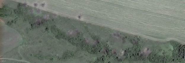
Figure 38 – July 16, 2014 Google Earth Image just west of Mala Shyshovka (47°54’47″N, 38°28’45″E) showing twenty GRAD missile craters
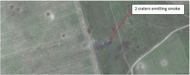
Figure 39 – July 16, 2014 Google Earth Image northwest of Blagodatnoe ( 47°54’3″N, 38°27’58″E) showing twenty GRAD missile craters
Given the direction of the craters, the missiles would have needed to be fired from Militia positions near Shakhtne, 15 km to the west-northwest. This also fits with the eyewitness
report provided below from an observer of the overnight fighting at Progress Mine that also summarizes and confirms the evidence from social media accounts.
July 16 – Municipal Gazeta – At Night There Was Fierce Fighting in the Donetsk Region[95]
Overnight, July 16, fierce clashes occurred in the area of Shakhtersk and Amvrosievka.
First, a video appeared on the Internet, where an armored column departs from Donetsk in the direction of Shakhtersk.[96] According to residents of Torez and Shakhtersk, active operations then began in their area.
“Ukrainian aircraft bombed a column of armored vehicles”, “Shakhtersk window shaking”, “the bombing started near Torez in the area Saur Mogila! Possibly it is Grad”, “Fired behind Torez in the side of the Saur Mogila! A little to the right than usual. Salvos are visible”, “B[olshaya] Shishovka – powerful combat, everything on fire. Info from those in Shaktarsk watching from the Microrayon,” “From the mine tower above Progress Mine in Torez over the 20th [mine] the fire and salvos are visible”, wrote the social network
users.
Given the direction from Progress Mine (48°04’58″N, 38°36’01″E) to the 20th Mine (48°02’23″N, 38°31’18″E), this would point to a launch point of the Militia near Shaktne for the Grad rocket artillery attack noted in the report of the Voice of Sevestopol. Similarly, the report of firing from behind Torez towards Saur Mogila must be outgoing Ukrainian fire from near Bolshaya
Shyshovka at Militia positions to the west.
This fire obtained a response the next day from the Militia as noted by two Tweets.
July 16 – Twitter @RomanenkSS – July 16, 2014, 8:16 am[97]
наше село Благодатное, Амвр. района за Украину, а нас вчера обстреливали с минометов, а ночью бомбили… Our village Blagodatnoe, Amvr[osiivka] region of Ukraine, yesterday we were shelled with mortars and during the night were bombarded …
July 16 – Twitter @zhopa_v – July 16, 2014, 10:32 am[98]
пгт сердитое гул с 8-30 слышен, сторона саур могила вел шишовка. вчера видела
3 колонны с 10 вечера. последняя в 11-50 – In the city heard a gruff rumble at 8:30 from the side of Saurovka leading to Shyshovka. Yesterday, I saw 3 columns [of military equipment] after 10 pm, the last at 11:50.
July 17 – warsonline.info – Novorossiya: The Operational Summary for July 16, 2014[99]
Several MLRS “Grad” of the Militia struck a checkpoint of the “National Guard” near the village of Bolshaya Shyshovka 6 km south of Shakhtersk – the results of the attack are
unknown. Between Shakhtersk and Torez, Ukrainian aviation from a great height tried to bomb the column of the Militia’s equipment, but missed.
Possibly the Grad attack mentioned is the crater field seen in the following Google Earth image in Figure 39. It is located along a field road between Mala Shyshovka and Bolshaya Shyshovka. The Grad attack in this image was made from the same general direction of Shaktne/Zhures as the crater fields seen in the previous pictures and thus by the Militia.
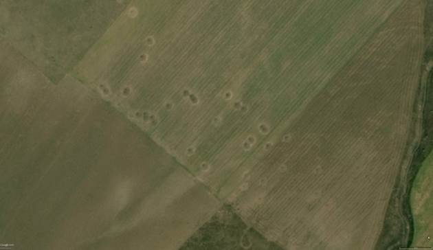
Figure 40 – September 14, 2014 Google Earth Image just north of Mala Shyshivka (47°56’13″N, 38°28’51″E) showing forty GRAD missile craters
July 17 – Burknonews.info – Anti-Terrorist Operation: Summary for July 16, 2014 [100]
The efforts of volunteers collecting information for the ATO forces, helped to find out
possible approach routes of terrorist reserves from Torez and reveal an attack group in the north of Amrvosievka. As it become known in the evening, good reinforcement to our forces arrived to Amrvosievka (we are not going to disclose any details to make that a surprise for terrorists).
At this time the Militia also continued making raids out of its Ilovaisk stronghold towards Kuteynikovo.
July 17 – Colonel Cassad – Fighting in Donbass, July 16–17[101]
At 4 am in the area of Metallist (northern outskirt of Kuteynikovo) the reconnaissance
and sabotage group of the 2nd Slavyansk battalion attacked the enemy strong point in the area of the unit of fire fighters. The Ukrs suffered significant losses in personnel. There are trophies.
It is notable that there are no corresponding raids into Blagodatnoe or Amvrosievka. The simple explanation of that was because the Militia held no positions near those towns, such as the field positions seen on space imagery around Bolshaya Shyshovka.
There is one final piece of evidence in determining control of the Zaroshchenske area on July 16, 17, and 18, 2014 that must be addressed. Bellingcat in page 27 of its report on Zaroshchenske [102] uses reference to a number of tweets concerning Ukraine gaining control of a village named Blagodatnoe on July 18. They use this as evidence that Ukraine only established a real military presence in Blagodatnoe after the shootdown of MH17. The unspoken conclusion is that if Ukraine was not in control of Blagodatnoe on July 17, then it could not occupy settlements further to the north.
As we have seen, this is not correct, and Ukrainian forces were present in the Blagodatnoe north of Amvrosievka even in June. The reason it is not correct is that there are actually three villages called Blagodatnoe in the area of the Donbass Conflict – one near Volnovakha definitely controlled by Ukraine since May, the one north of Amvrosievka, and one between Artemovisk and Soledar north of Gorlivka. The reports referenced by Bellingcat, actually make this clear. After an initial euphoric reaction by supporters of Kiev in the Torez area who were not actually aware of the situation on the ground and thought that Ukrainian troops were coming close to their city, responses came in clarifying that this was the Blagodatnoe near Soledar.
July 18 – Twitter @YevhenS – July 18, 2014, 22:49 pm[103], @NikolasFather – July 18, 2014, 22:51 pm[104]
Зелло, украинская армия взяла Благодатное… – Zello, the Ukrainian Army took Blagodatnoe…
Вау, это совсем рядом с моим домом! Молодцы, ребята! Возвращайтесь живыми! – Wow, that is very near my home! Well done guys! Please come back alive!
July 19 – Twitter @melanhaton – July 19, 10:43 am[105]
Армия готовится отрезать террористов Лисичанска от основных скоплений
Украинская армия взяла Благодатное. – The Army is getting ready to cut off the Lisichansk terrorists from the main group Ukrainian Army took Blagodatnoe.
While this might be obvious now, at the time it remained a source of confusion and misinformation for people in the surrounding area and interested in the conflict until after the Battle for Blagodatnoe on July 23rd to 25th, 2014 decisively settled control of the town for the subsequent month. It is quite notable that people in Torez had no idea who was
in control of the villages just to their west.
With these reports, we have a coherent picture of actual military control of the area of Zaroshchenske. Along the T0517 Ukraine was in control of all the settlements between Amvrosievka and Bolshaya Shyshovka. On right side of this road, the Militia controlled the settlements of Ilovaisk, Stepano-Krynka, and Shakhtne. On the left side, the Militia held Torez and Saur Mogila, including Petrivske, Manulivka, and Ternove. As can be seen on the map below in Figure 41, this corresponded to the natural boundaries of the region, which makes sense
given the lack of an overall continuous front.
Most importantly for the thesis of this paper, a clear line of transport completely under Ukrainian military control via the field road from Blagodatnoe is available to Ukraine to deploy its BUK-M1 TELAR’s from Amvrosievka to the field in Zaroshchenske where Russia captured them on a satellite image.
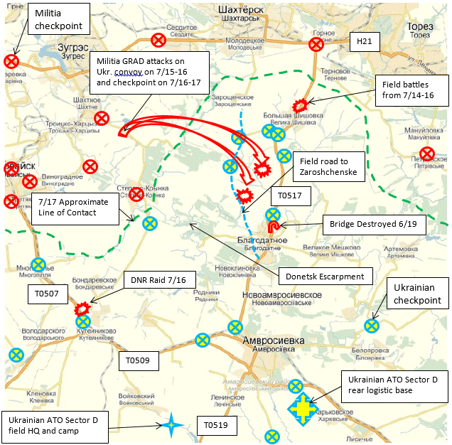
Figure 41 – Reconstructed Military Situation Map of Area of Zaroshchenske for July 16 to 18, 2014 Showing Checkpoints, Field Bases, Battles, and Approximate Line of Contact.
This map should be compared to the map of the Ukrainian NSDC shown previously in Figure 3. The entire area actually occupied by Ukraine on this map and covered in Ukrainian manned checkpoints and field camps was shown on the NSDC map as “controlled” by the Militia. The location of the Ukrainian forces can be confirmed on Google Earth imagery from July 16, 2014 and correlated to the reports above and many additional reports also to be found at the social media and military report sources cited. Because of this, we are able to investigate the positions of the Ukrainian military at Bolshaya Shyshovka and Shaposhnykovo in greater depth and confirm the social media reports concerning military control of that area, and thus the ability of the Ukrainian
Armed Forces to deploy two BUK-M1 launchers to Zaroshchens’ke on July 17, 2014.
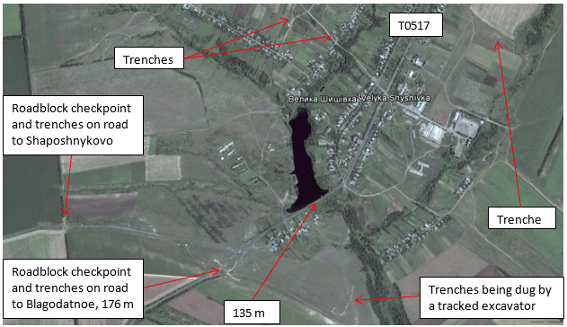
Figure 42 – Overview of Bolshaya Shyshovka (Velyka Shyshivka) on Google Earth, July 16, 2014
Around noontime on July 16, Bolshaya Shyshovka was a beehive of military construction activity. All of this activity and the purpose of the military field works were misinterpreted by Bellingcat in their analysis of these sites.
On the northeast and northwest sides of town trenches had been dug facing the farm fields. The purpose of these trenches is to provide safe military surveillance capabilities of the fields north of town for combat infantry and protect them from incoming artillery fire from the north. Such trenches would serve no military purpose for the DNR Militia, since they were in undisputed control of the towns of Shakhtersk and Torez to the north, and
they would be the party firing artillery from the north.
Inside town, trenches are dug around a single house that probably serves as a company headquarters location for the occupying troops.
On the southeast side of town east of a new roadblock on the T0517 highway, a series of long trenches two deep was being dug in on a hillside by a tracked excavator at elevations between 155 and 139 meters. These trenches provide the same function as the trenches to the north. In this case, the trenches are facing field roads coming from the Militia positions in Petrivske and Manulivka on the west flank of Saur Mogila that were held by the Oplot (Stronghold) Battalion.
The roadblock checkpoint on the T0517 is facing north and protects the approach southwards from vehicles approaching from town. The checkpoint is located at the top of a rise at an elevation of 176 meters and has excellent commanding views of the entire surrounding landscape which it towers over by a height differential of 15 to 50 meters. This can be seen in a photo available on Google Panaramio shown below.
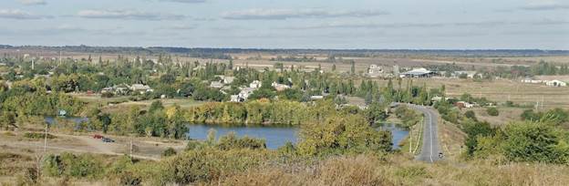
Figure 43 – View northeastwards towards Torez from roadblock checkpoint on T0517 highway south of Bolshaya Shyshovka, from Google Panaramio
It is of course standard military practice to locate major fortifications at the top of a hill where your enemies need to fight on an upward climb to reach you. This particular roadblock faces a rise to the southwest and the direct southern view is immediately obscured by trees, meaning that if the Militia had located here, the Ukrainians would have the advantage of charging down at them in a battle or making a blind approach from behind several rows of trees and taking them in an ambush. It is obvious the checkpoint was installed at this location to provide a long range view of vehicles moving in the north or from north to south, which could only mean Ukrainian surveillance of possible Militia movements, as the Milita would not need to watch for itself coming out of Torez or Shkhtersk.
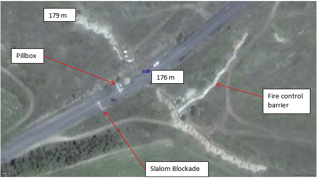
Figure 44 – Roadblock Checkpoint on T0517 South of Bolshaya Shyshovka on Google Earth, July 16, 2014
The detailed layout of the roadblock also clearly shows it is a northward facing strongpoint. The pillbox, which would have included a heavy machine gun, is facing northwards to control southbound traffic arriving from Militia controlled areas. Northbound traffic from the south is controlled by redirection using a slalom course. The two long side trenches prevent vehicles from driving around the roadblocks. The one on the north side is also at a higher elevation than the checkpoint by 1 to 3 meters which helps affect control of the entire fortification. The long earthwork running parallel to the road is actually accumulated dirt spoils from the excavation piled up on top of the land to build up its height. This part of the foritifcation provides for additional fire control of suspect vehicles stopped in front of the pillbox that have approached from the north since the land it is on is about 1 meter lower than the road. This barrier serves no purpose if this were a theoretical Militia checkpoint since it would be pointed against the rebel populace instead
of potential infiltrating Ukrainian vehicles from the south.
In the July 16, 2014 satellite photo, the T0517 checkpoint has visibly just been constructed. The trenches are brand new and a second tracked excavator is seen waiting to be loaded onto a low-loader trailer at the intersection just to the north. This conforms to our thesis that Ukraine just won this town.
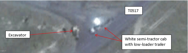
Figure 45 – Semi-tractor with low-loader trailer waiting to pick up tracked excavator on Google Earth, July 16, 2014 (47°57’57″N, 38°30’17″E)
The roadblock checkpoint on the road to Shaposhnykovo has a nearly identical design to the roadblock on the T0517 and is facing westwards, again to control traffic coming from Bolshaya Shyshovka and the north but this time attempting to enter Shaposhnykovo village. The roadblock has two pillboxes facing west blocking both lanes of traffic, side trenches to the north and south to the adjacent treelines to prevent vehicles from going around the roadblocks, a slalom of roadblocks behind the pillboxes, and a side trench
to provide fire control of westbound vehicles stopped at the roadblock. The roadblock is located at an elevation of 202 meters, with the road to the west being at 204 meters and the road to the east at 199 meters, clearly showing the orientation of the site. The orientation and location of the roadblock makes it clear it is a Ukrainian military field work.
On the other hand, for the Militia, this could not possibly be a location of any significance. If the Militia only controlled Bolshaya Shyshovka, the roadblock would be oriented backwards. Theoretical Ukrainian troops approaching from the west would have the advantage of elevation and the pillboxes would not face them. If the Milita was in control of both Bolshaya Shyshovka and Shaposhnykovo following the Bellingcat thesis, this roadblock could not possibly serve any military purpose at all, since access to this location from the south would be impossible without having previously passed a Militia checkpoint. The Militia lacked the manpower to occupy locations that for them were so militarily pointless.
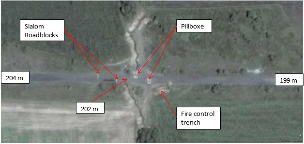
Figure 46 – Roadblock Checkpoint on the road to Shaposhnykovo on Google Earth, July 16, 2014
This fortification is of special interest to this investigation because the place it is “protecting”, Shaposhnykovo, is a village of absolutely no strategic military importance at all and certainly not a location justifiying of itself the effort to create this roadblock. It is
therefore amazing that a large fortification has been constructed to prevent infiltration to this settlement from the east. This location does have a critical tactical importance to Ukraine – it protects one of the approaches to the location of the deployment of Ukrainian BUK-M1 launchers on July 17, 2014 and would allow Ukraine to prohibit anyone from approaching this temporarily sensitive site if they were to so choose.
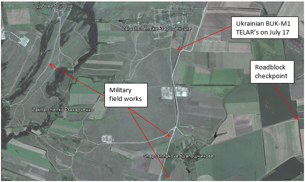
Figure 47 – Overview of Zaroshchens’ke and Shaposhnykovo on Google Earth, July 16, 2014
At Shaposhnykovo itself, there three or possibly four more small fortifications to be seen.
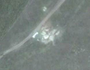
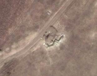
Figure 48 – Fortification south of Shaposhnykovo on Google Earth on July 16 and September 13, 2014
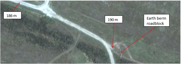
Figure 49 – Roadblock fortification 4 km south of Shaposhnykovo on Google Earth on July 16, 2014 (47°55’50″N, 38°25’36″E)
The first military field work appears to provide protection of Shaposhnykovo village from traffic on the roads to the southwest. Due to the obstruction of the Donetsk Escarpment, these roads all lead primarily to the town of Stepano-Krynka which was occupied by the Militia on July 15, 2014. It is therefore clearly a Ukrainian fortification.
The second blocks the field road from Stepano-Krynka to Mala Shyshovka and Blagodatnoe and has a controlling view of the road from Stepano-Krynka where it turns north to Shaposhnykovo.
There is a third site, the exact use of which is less clear, west of Shaposhnykovo.
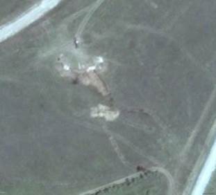
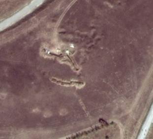
Figure 50 – Field works west of Shaposhnykovo on Google Earth on July 16 and September 13, 2014.
One possibility for this site is that is a small illegal coal mine. Such mines are found throughout Donbass. Both the July and September pictures show excavators at the site and the ground north of site appears pockmarked in September as if coal pits have been dug there. For an example of a small coal mine, see the field works up to 1 km out from around this coordinate (47°57’44″N, 38°19’11″E. It is also possible that it is a military fortification. The site is at an elevation highpoint of 197 meters, so it provides a good communication point to the roadblock checkpoint east of Shaposhnykovo and the small fortification south of Shaposhnykovo. It also has a clear line of site to the location south of Zaroshchenske where Russia imaged the Ukrainian BUK-M1’s. Another possibility is it may be a dual use site where an existing coal mine was seized temporarily for military purposes.
The fourth site is on the field road from Stepano-Krynka and Rusko-Orlivka to Dubove and Sadove. There is a small fortification built to the west side of the road at the end of a rise from the south at an elevation of 174 meters. This fortification controls access to the west flank of Zaorshchens’ke via field roads leading through the woods and over a creek near the village of Zakharchenko.
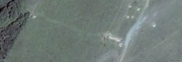
Figure 51 – Field works south of Dubove on Google Earth on July 16, 2014 (47°58’52″N, 38°24’32″E)
This location serves no purpose for the Militia, as it would be sitting astride a little used field road between two of their positions – Stepano-Krynka and Sadove – not requiring any protection if the Ukrainians weren’t closer than Blagodatnoe as asserted by Bellingcat. In August, Ukraine developed this area into a much larger artillery position devoted to outgoing fire on Militia positions to the west and north. This position is dicussed by a Twitter user @audrius1977 who lived in Viktoriya (Виктории) just north of Shakhtersk:
August 4 – Twitter @audrius1977 – August 4, 2014, 12:26 pm[106],
17:52 pm[107]
Где то час назад днровцы из Шахтёрска и Тореза вели сильный артобстрел Кантарное-Орловка-Ивановка и на юг за Дубовое. – About an hour ago the DNR Army somewhere out of Shakhtersk and Torez were heavily shelling Kantanoe-Orlovka-Ivanovka and to the south of Dubove.
When asked by a now deleted account (@privet12345678) where the nearest Ukrainian Army positions to Shakhtersk were @audrius1977 replied:
на юге у Дубовое . На шахте Винницкой вчера по крайней мере был наш
блокпост – To the south of Dubove. Yesterday at least on the Vinnitsya Mine was our post.
(The Vinnitsya Mine mentioned is an abandoned mine north of Shakhtersk at Stojkovski [Russian: Стожковскоe/ Ukrainian: Стiжкiвськe]).
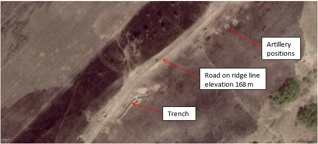
Figure 52 – Additional Ukrainian Army field works south of Dubove on Google Earth on September 13, 2014 (47°58’39″N, 38°24’30″E)
Thus it would appear that every filed work found north of the Krynka River is actually a Ukrainian army post, and not something constructed by the Militia.
There is one final method of verifying that the fortifications and field works in the area of Bolshaya Shyshovka and Shaposhnykovo were under Ukrainian control on July 16 to 18, 2014. On July 26, Ukraine initiated an offensive operation to seize control of the towns of
Shakhtersk and Torez to the north of this area. This offensive ultimately failed, but throughout the period of July 26 to August 21, 2014, the Ukrainian Armed Forces were occupying the villages of Dubove, Ternovo, Manulivka, and Petrivske to the north and west of the region in question. They even shelled and destroyed the Militia checkpoint on the H21 Highway at the junction of the T0517 highway on July 27. On the same day they also attempted unsuccessfully to advance into Stepano-Krynka and thus breach towards Ilovaisk. There are numerous confirmations of this strategic advance by the Ukrainian Armed Forces. It is very telling is that to make this advance, there is no sign in satellite
imagery from September 13 & 14, 2014 of Ukraine having to shell and destroy Militia positions in the town of Bolshaya Shyshovka.
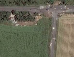
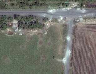
Figure 53 – Militia Checkpoint 20 the junction of the H21 and T0517 Highways (48°01’56″N, 38°32’25″E). Left: July 24, 2014, Right: August 4, 2014 on Google Earth. Note the destruction from the battle.
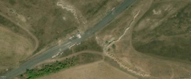
Figure 54 – Ukrainian Bolshaya Shyshovka Checkpoint on the T0517 Highways (48°01’55″N, 38°32’25″E). September 14, 2014 on Google Earth. Note no sign destruction from any battle. Compare to Figure 44.
Additionally, other than a single trench on the north side of town along the T0517, no other military field works appeared near Bolshaya Shyshovka and Shaposhnykovo. It would seem incredible that field works that according to Bellingcat were supposedly used by the Militia for southward facing positions were all able to be turned around and used as northward facing positions by Ukraine. Of course the obvious answer is that as we have shown above, these positions were always Ukrainian positions from around July 15/16, 2014 onwards. This leads directly to the conclusion that there was not a large battle to
advance through this area on July 26/27 because Ukraine was already occupying the towns.
A selection of military reports and social media posts about this Ukrainian offensive follows. None of them describe an attack on Bolshaya Shyshovka or Shaposhnykovo.
July 26 – Twitter @zorezlit – July 26, 2014, 20:37 pm[108]
ЗЕЛЛО: Путинцы кричат о большом количестве украинских танков, идущих через Благодатное на Шахтёрск. Пытаются что-то предпринимать. – ZELLO – Putin’s people screaming about a large number of Ukrainian tanks going via Blagodatnoe to Shakhtersk. Attempting to attack something.
July 27 – Icorpus.ru – Summary from the Headquarters of the Militia DNR 27.07.2014
11:50 GMT[109]
Stepano-Krynka was defended, the attempted offensive of the enemy with a large amount of equipment was defeated. The enemy suffered significant losses. 9 hits in armor, 3 units of armored vehicles guaranteed destroyed.
July 27 – Burkonews.info – Anti-Terrorist Operation: Summary for July 27, 2014[110]
The ATO forces continue to advance upon Shakhtersk and Torez from the south. The terrorists did not expect them from that direction because they thought that they control the situation by constant shelling both from the north and the territory of the Russian Federation.
Note that this report report from the Ukrainian side speaks of the militia trying to control the territory south of Shakhtersk through shelling, and not through physical occupation of the 13 km of land up to the approaches to Blagodatnoe. This is a de facto confirmation that prior to this attack, Ukraine already held the area north of Blagodatnoe.
July 28 – Slavyangrad.org – Igor Strelkov Press-Conference, July 28, 2014: The Latest Ukrainian Offensive Mostly Repulsed[111]
I[gor] S[trelkov]: So—today, the Militia was engaged in heavy fighting in the area of the cities of Shakhtersk, Torez, Snezhnoye; in the area of Saur-Mogila; in the area of the strategic height 198.3; and in the area of Marinovka and Stepanovka. The battles were particularly fierce. The enemy, by means of strikes from the south and from the north, is attempting to complete the encirclement of the Donetsk grouping of the Militia.
At this time, the battle taking place directly between Shakhtersk and Torez is ongoing. The Militia is attacking the enemy, seeking to force it out of the strategically important Checkpoint No. 20, which is located at a T-junction between Torez and Shakhtersk.
I can say that the enemy has engaged in these battles today a quantity of armoured equipment that even to me appears unusual. In other words, I’d say that as many as two hundred or even two hundred and fifty armoured vehicles were involved—to be honest, I’m having difficulty estimating how much armour the enemy engaged in battle today. Simultaneous strikes were, I repeat, commenced from the north and from the south. The attacks were directed at Snezhnoye, Torez, Shakhtersk, Saur-Mogila, Stepanovka, and Marinovka.
There is of course no mention of attacks of Bolshaya Shyshovka by Colonel Strelkov.
July 30 – Twitter @vladicvp – July 30, 2014, 20:39 pm[112]
#Шахтерск с с *Большая Шишовка* артиллерия бьет по 8у микрорайону (Журалевка ) #zello – #Shakhtersk from the settlement *Bolshaya Shyshovka* artillery strikes on the 8th microraion (Zhuralevka) #zello
August 8 – Burkonews.info – The Anti-Terrorist Operation in Ukraine: Summary for August 8, 2014[113]
Besides these maneuvers, ATO forces have moved towards Torez and Snizhne from the southwest via Velyka and Mala Shyshivka effectively preventing the terrorists from counter-attacking on the wing of the ATO forces in Saur-Mogila.
August 10 – Twitter @masliuta – August 10, 2014, 22:13 pm[114]
в центре Тореза ощущаются взрывы у с.Терновое (Б.Шишовка) -на линии фронта Саур-Могила-Шахтерск – In the center of Torez felt explosions in the settlement of Ternove (Bolshaya Shyshovka) – on the frontline Saur-Mogila – Shakhtersk
August 19 – Burkonews.info – The Anti-Terrorist Operation
in Ukraine: Summary for August 19, 2014[115]
The H21 highway is still under the control of terrorist forces, however the armed forces of Ukraine are able to target fire in the area of Molodetsk and Velyka Shyshivka. Considering the constant clashes in the area of Savur-Mohyla, the advance towards Shakhtersk, Torez and Snizhne has been suspended for now. Besides, the problem of the trap in the area of Manuilivka-Petrivske and Savur-Mohyla still needs to be resolved. Here we can expect the terrorists’ attempt to liquidate the besieged Ukrainian forces; the strikes are most likely from the side of Donetsky Kryazh and Stepanovka. However the terrorists lack forces, especially considering the significant ATO force grouping in the area of Velyka and Mala Shyshivka. Anyway the fact remains that H21 highway has not been blocked and is constantly used for the enemy’s motor convoys.
August 21 – Slavyangrad.org – Map of Novorossiya Hostilities (English), Aug 10-22, 2014[116]
On August 21, the Militia took control of the settlements of Petroskoye [Petrivske] and Manuilovka to the south-west of Snezhnoye.
August 22 – Burkonews.info – The Anti-Terrorist Operation in Ukraine: Summary for August 22, 2014[117]
As a result of the fights around Savur-Mohyla Ukrainian forces had to withdraw from Manuilivka and Petrivske, which are just sound of Torez. Terrorists propagandize in their channels that they expelled Ukrainian forces; however, this is not true because Ukrainian forces withdrew on their own in order not avoid being cut off should Saur-Mohyla fall.
Ilovaisk was unfortunately abandoned by Ukrainian forces. The DNR terrorists had large reserves of Russian military equipment and they were able to bring them to bear on the Ukrainian troops in that area. In addition, the Ukrainian forces had to abandon Velyka Shyshivka as well.
This report is also of interest because it confirms that the Ukrainians withdrew from Bolshaya Shyshovka without a fight at the checkpoints, exactly what is seen in Figure 54.
August 23 – Twitter @audrius1977, August 23, 10:18 pm[118], @serpentkiller3, 10:28 pm[119], @audrius, 10:30 pm[120], @serpentkiller3, 10:34 pm, @audrius1977, 10:45 pm[121], @serpentkiller3, 10:51 pm[122], @audrius1977, 11:03 pm[123], @serpentkiller3, 11:05 pm[124]
А Благодатное точно под террами? – And is Blagodatnoe controlled by the Terrorists?
ну РНБО 20 или 21 сказало, что проводится операция по установлению
контроль над этим н.п. И дальше тишина. – Well, RNBO on the 20th or 21st said that the operation is performed to establish control of this settlement.
Ну тогда непонятно куда могли отойти из Мануйловки наши А там техники было немало Да и врорде сепары видели наших в Шишовке – Well then, it is
unclear where our people could have departed to from Manulovka as there was a
lot of equipment. And I think sepra[tists} saw our people in Shyshovka.
да, я вот тоже не понимаю, как наши держали позиции в Терновом, если
Благодатное не было занято. – Yes, I too don’t understand how our guys kept a position in Ternovo if Blagodatnoe was not occupied.
Благодатное давно было наше 100 процентов Если отдали то только на
днях Но непохоже надеюсь, я недопонял рнбо – Blagodatnoe long ago was 100 percent ours. If it surrendered it was just the other day. But however unlikely, I hope I misunderstood the RNBO.
Может была попытка терров отбить – Maybe there was an attempt to repel the terror[ists].
ну, если ушли от тернового и мануйловки, вполне могло быть – Well, if we retreated from Ternovo and Manulovka, it certainly could be.
The question needs to be asked where the Militia was on July 16 to 18, 2014 if they were not in Bolshaya Shyhovka, Shaposhnykovo, and Zaroshchens’ke. This is answered by an article about the July 27th offensive from a Militia source.
July 30 – Colonel Cassad (English) – “End of July Activity”, M. V. Litvinov [125]
Despite all of these problems, the punitive troops made their principal bet on the breakaway towards Debaltsevo – Shakhtersk. And on July 23rd they initiated fighting for the initial areas of this offensive – Debaltsevo and Blagodatnoe. On July 24th they managed to secure Blagodatnoe, but the fighting for Debaltsevo didn’t give the necessary result – they couldn’t push the stubbornly defending militia units out of there. In this situation the punitive corpus command decided to repeat the same approach that already brought success to it in Artiemovsk and threw a battalion tactical group of the 95th separate airborne brigade bypassing Debaltsevo directly on Shakhtersk during the night of July 26th and 27th. Apparently, the DPR militia, being fully devoted to fighting for the “Marinovka corridor” and for Debaltsevo didn’t expect such a move. The breakthrough was fully successful. The reason for this success is that the DPR militia, seeking to have a continuous front line, does not have the ability to maintain forces that are necessary for successful defense in the key points behind the defensive lines.
The militia forces in Shakhtersk didn’t exceed a single company, which wasn’t concentrated into a fist, but rather was scattered at checkpoints. Keep in mind that it is necessary to have at least 200-300 fighters within a settlement in order to repel an assault of a battalion tactical group. And in general the minimally required garrison in such a settlement – 500 fighters. The main forces of the 2nd and 3rd
battalions of the Slavyansk brigade were located south of the line Torez –
Shakhtersk – Zuhres – Khartsyzk. As a result, the punitive troops, effectively
without encountering resistance, established company-level strong points in the
areas of Gornoye and Olkhovchik, cutting the shortest routes from Donetsk to
Snezhnoye. The militia forces at that moment were bound by the attacks from
the front in the area of Stepano-Krynka. And even though the attacks of
the punitive troops in this area were repelled, the punitive forces in Shakhtersk
joined with the main forces of Amvrosievka group of the armed forces of Ukraine
that were arriving from the side of Blagodatnoe.
So in the middle and end of July the main body of Militia troops available in this area were in the north near Debaltsevo, in the southeast near Marynivka and Saur Mogila (where the 3rd battalion of the Slavyansk Brigade was fighting with the Vostok and Oplot battalions) and in the southwest near Iloviask and Stepano-Krynka (where the 2nd battalion of the Slavyansk Brigade was located), and in the remaining territory were only scattered Militia troops at key checkpoints on the main highways.
Reports from July 21 to July 25 – The Shelling of Shaposhnykovo
There is one final series of events to investigate from the military reports and social media. After July 16, there is a period of quiet in military reports of the Shaposhnykovo-Bolshaya Shyshovka area until the Russian MoD gave their presentation on Ukrainian BUK deployment on July 21, 2014, highlighting the deployment of BUK’s to Zaroshchens’ke . Within hours of this
presentation, a most curious set of events began to take place. Rocket artillery companies from Ukraine’s 72nd Mechanized Brigade camped at Amvrosievka undertook a massive GRAD rocket attack into the village and surrounding fields of Shaposhnykovo just south of Zaroshchens’ke. Attacks then continued periodically for several days.
July 22 – Sevas News – Settlements of Donbass once again under fire. There are victims.[126]
The village Krasnogorka in the West of Donetsk and the village of Shaposhnykovo in 22 km from the crash site “Boeing” were shelled with “Grad”.
Several people died and were injured during the shelling of villages Krasnogorka and Shaposhnykovo in the Donetsk region. On July 22, RIA Novosti reported
about it, citing its own correspondent in the war zone in Eastern Ukraine.
According to the journalist … In the village of Shaposhnykovo due to the firing of Grad an elderly woman was killed and another local resident was injured.
This is an extremely modest way of describing this startling incident. In less than a 24 hour period the Ukrainian military drove out to a field just east of Amvrosievka 15 GRAD BM-21 trucks.
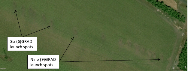
Figure 55 – September 14, 2014 Google Earth Image just west of Amvrosievka (47°47’33″N, 38°26’31″E) showing 15 launch locations of GRAD rocket artillery trucks used from the late afternoon on July 21, 2014 into the day on July 22, 2014
These trucks each fired a full load of 40 missiles each with a warhead of 20 kg, so 12,000 kg total of warhead explosives. This is only slightly less than the bomb payload dropped
on Japan in the famous Doolittle raid during World War II. Six trucks were placed to the west, targeting the field and the field road south of the settlement Zakharchenko (47°57’58″N, 38°24’51″E) with 240 rounds of rocket artillery. Another 9 trucks were placed center and east targeting Shaposhnykovo itself with 360 rounds. As this is one of the largest single artillery attacks during the war in Donbass and the village itself is covered
in craters, it is beyond belief that casualties were a single elderly woman and no soldiers of the DNR Militia, who are not even mentioned as being present in the settlement and thus justifying the attack!
It is extremely difficult to think of a rational military reason for conducting this intimidating attack on this location and in this scale. It is incredible that Ukraine felt a need to attack here with such disproportionate force mere hours after Russia revealed a satellite photo of a field near Zaroshchens’ke just to the north showing two Ukrainian BUK-M1 TELAR vehicles in range of MH17. The crater field from this attack is so vast and expansive, covering over 4 km of breadth, that it could be clearly seen from space, which is the best way to get a perspective on this size of this attack.
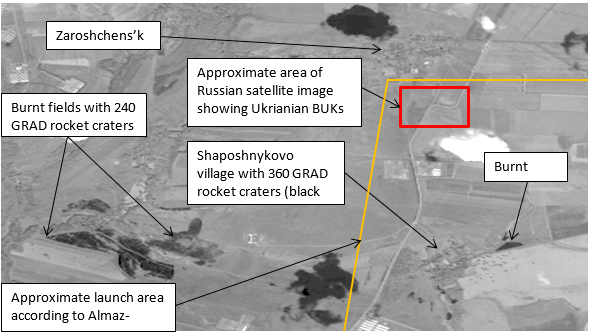
Figure 56 – Digital Globe preview image of the villages of Zaroshchens’ke, Shaposhnykovo, and Zakharchenko (Catalog No. 1020010031316300) July 23, 2014
A second article on this attack is equally remarkable and makes an incredible set of juxtapositions.
July 22 – RIA – Militia: Malaysian experts came under fire of the Ukrainian aviation[127]
DONETSK/BALI (Indonesia), 22 Jul — RIA Novosti. A group of Malaysian experts who tried to go to crash site of the Boeing came under the fire Ukrainian aviation, RIA Novosti was informed by the representative of the militia that accompanied the aviation experts. …
… around Torez a Sukhoi fighter was seen, which struck near Snizhne. In addition, Ukrainian artillery shelled the village of Shaposhnykovo located 20 km [sic] southwest of Torez. On the morning of 22 July it is expected the
Malaysian experts will make another attempt to reach the crash site. …
A repetition of the tragedy of 2001?
The reasons for the crash Malaysian liner are still unclear. Since April in the area of the crash, the Ukrainian security forces are conducting the so-called
anti-terrorist operation (ATO) against the residents of Donbass disgruntled by
the February coup. The operation includes use of aviation, heavy artillery and
systems of missile fire.
According to experts, the military equipment used by the Ukrainian army was obtained from the Soviet Union and its use in the course of military operations may well lead to a repeat of the tragedy with the Russian passenger plane shot down by Ukraine in the sky
over the Black Sea in 2001.
Then, during exercises of Ukrainian air defense units of the missile complex S-200, a
Russian Tu-154 en route Tel Aviv — Novosibirsk was shot down, killing 78 people
…
The article connects together (1) the crash of MH17, (2) the attack by Ukraine on the Malaysian experts as they attempted to access the wreck site, (3) ongoing aerial combat
operations by Ukraine in Donbass, (4) the mass shelling of Shaposhnykovo, and (5) the Ukrainian shootdown of Siberian Air 1812 during air defense exercises in 2001. The logical thread connecting these disparate events into a single whole is what Russia revealed in Figures 1 and 2 above – Ukrainian BUK’s deployed into the kill zone of MH17 north of Shaposhnykovo near Zaroshchenske.
Given the findings of Almaz-Antey, it is likely that the BUK’s placed south of Zaroshchenske in the morning of July 17 and photographed by Russia were relocated southwards nearer to Shaposhnykovo or even Mala Shyshovka in the afternoon, an area where they could still fire and hit MH17 and produce the same result. This leads to the
suspicion that this massive GRAD attack, coming almost immediately after the
Russian revelations, was intended as a cover-up of evidence or an intimidation of the local residents who might have seen something. Besides reporting about the event on local chat boards, locals also immediately voiced the same suspicion.
July 21 – Vkontakte Overheard in Shakhtersk – July 21, 2014,
18:04 pm[128]
Подслушано Шахтерск: а в17.30 примерно что прогремело? и где? – And at about 17:30 what happened? And where?
Yury Kosnitsky: Это Шапошниково обстреляли( – That was Shaposhnykovo being fired at
Katyushka Vovk: у нас соседку в шапошниково убило на даче была – Our neighbor was killed in Shaposhykovo. She was at the dacha.
Nikita Sinyak: Я домой ехал,видел дым между шахтерском и зугресом – I went home and saw the smoke between Shakhtersk and Zhures
Tatyana Gladunova: Шапошниково – Shaposhnykovo
July 22 – Vkontakte Overheard in Torez – July 22, 14:33 pm[129]
Подслушано в Торезе : кто вкурсе где опять херячат? – Does anybody know where the bombings are happening again?
Elena Mikhaylova: Где-то в стороне Шишовки – somewhere near the side of
Shyshovka
Yana Gmyrya: У нас в шахтерске мне с балкона видно в поле за посадкой
пыль столбом стояла,вчера тоже там бомбили.может и вам слышно – We
are in Shakhtersk. From my balcony I saw the impact in the field and the column of smoke in the air. It was also bombed yesterday. Maybe you heard?
Elena Shlyakhova: Из Амвросиевки грады работают постоянно. – From
Amvrosievka Grads are constantly firing.
Elena Mikhaylova: И вчера, и сегодня это Шапошниково, возле
Шишовки – And yesterday and today its Shaposhnykovo, near Shyshovka.
Sergey Sukhomlinov: Второй день лупят по Зарощенску(5 км от Шахтерска),
вот фото со спутника выложенное до атак градами. делайте выводы сами.
мое мнение, заметают следы … – This is the second day they fire on
Zaroshchenske (5 km from Shakhtersk), here is a photo from the satellite, lined
up to attack in a hail of fire. Make your own conclusions. My opinion, the’re
covering their tracks.
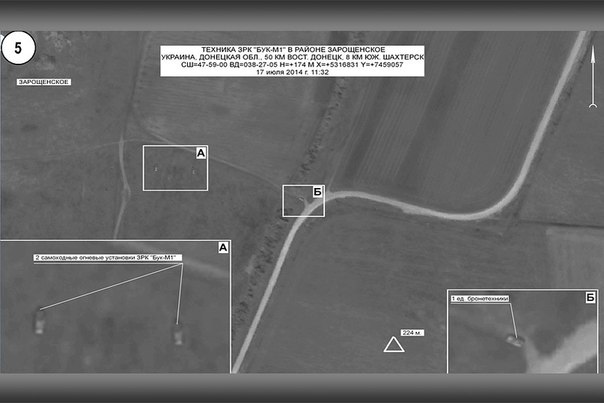
Yulia Grigorets replied to Sergey Sukhomlinov: Сергей, очевидцы говорят что под Шишовкой за птичниками. – Sergey, eyewitnesses say its near Shyshovka at the poultry houses.
Sergey Sukhomlinov replied to Yulia Grigorets: Юлия, Зарощенское
там и находится,просто все зависит от того, с какой стороны смотреть
– Yulia, Zaroshchens’ke is there, it all just depends on which way you look
There are no references at all to any fighting between July 17 and July 21 indicating the Militia moved into Zaroshchens’ke or expelled Ukraine from Shaposhnykovo. It is likely that Ukraine quietly withdrew from its positions near Shaposhnykovo before firing on the surrounding area with Grad.
There are also two tweets about this incident that confusingly attribute the destruction to aerial bombardment by the Ukrainian Air Force, clearly showing a lack of knowledge of the actual event.
July 22 – Twitter @ma_singer – July 22, 2014, 00:46 am[130]
Через неск часов после объявления Порошенко прекращ. огня в р-не падения
боинга, боевые самолеты нанесли удар по селу Шапошниково (22км Тореза) – Several hours after Poroshenko’s announcement of a ceasefire, there is fire in the region of the Boeing crash as war planes deliver a strike on the village of Shaposhnykovo
(22 km from Torez)
July 22 – Twitter @masliuta – July 22, 2014, 17:36 pm[131]
Шапошниково (возле Б.Шишовки) разбомбили- боевики засели), 1 житель погиб.
Сама БШ (Шахт р-н) ждет фронт: тут полно сепаров – Shaposhnykovo (near B[olshaya] Shyshovka) destroyed by bombing – militants were occupying, 1 person was killed. B[olshaya] Sh[yshovka] (Shakhtersk region) itself watches for the frontline. It’s full of separatists.
This single tweet from @masliuta is all that the author has found as evidence in apparent contradiction of the thesis of this paper. She further embellishes the account with imaginative references to entrenched DNR militants who are also still occupying Bolshaya Shyshovka even though we have seen they were driven out of the town on July 15/16.
The information from this account does not always appear 100% reliable in its assertions of facts on the ground about the Militia. In a tweet from August when every other report and map shows Bolshaya Shyshovka occupied by Ukraine and well behind the front line at Ternovo (which she herself is aware of – see her Tweet from August 10th in the previous section), she sees it full of Ossetians, i.e. “Caucasian Terrorists” supposedly
making up the Vostok Brigade of the DNR in the minds of Ukrainian patriots:
August 11 – Twitter @masliuta – August 11, 2014, 16:15 pm[132]
в с.Большая Шишовка(Шахтерск) боевиков ничто не пугает:сидят
осетины прочно, чего-то выжидают, окапываются.Уходить им некуда?С-Могила тю-тю – In the village of Bolshaya Shyshovka (Shakhtersk) nothing scares the militants: Ossetians are hanging firm, waiting for something, digging trenches. They have nowhere to escape? S[aur]-Mogila bye-bye.
To return to the subject of the bombardment of Shaposhnykovo, the rocket artillery attack on this area was amazingly continued over subsequent days as Ukraine found the time to fire and at least another 5 trucks loads of Grad missiles were sent into the area just south of the previous attack. 80 rockets hit fields either side of the coordinates 47°57’11″N,
38°25’11″E. Another 120 rockets hit the area southwest Shaposhnykovo on the road leading to Stepano-Krynka to the southwest and to Blagodatnoe and thus Amvrosievka to the southeast. We note that given the attack on the Ukrainian convoy on July 15/16 along this route and the lack of any settlements along it this was also the likely route of the Ukrainian BUK’s to reach Zaroshchens’ke.
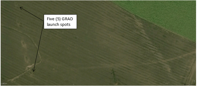
Figure 57 – September 14, 2014 Google Earth Image just west of Amvrosievka (47°47’22″N, 38°26’18″E) showing 5 launch locations of Ukrainian GRAD rocket artillery trucks used around July 25, 2014
July 25 – Twitter @Helgi__UA – July 25, 2014, 10:29 am[133]
Шахтерск. Мощный залп ГРАДА со стороны Амвросиевки.Второй с утра.Гораздо
ближе чем вч и позавч. – Shakhtersk. A powerful volley of Grad from Amvrosievka. The second morning. Much closer than y[esterday] and the day before yesterday.
The distance reference refers to the attack being much closer to Shakhtersk on July 25, compared to the artillery attacks on July 23 and 24. Those were further south at Blagodatnoe due to the battle in that town and the attacks by the Militia from both Stepano-Krynka and Petrivske into
Blagodatnoe.
July 25 – Twitter @Myhomeborisov – July 25, 2014, 15:22 pm[134]
кстати град в 10-40 лупил по хутору Шапошниково. Дым черный потом валил – By the way “Grad” at 10:40 beat the farm settlement of Shaposhnykovo. Black smoke then fell.
The results of these additional attacks can also be seen in space imagery from Digital Globe and are summarized along side the initial attack on July 21/22 in Figure 57 below.
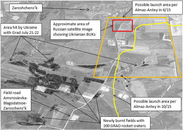
Figure 58 – Digital Globe Preview Image (Catalog No. 1020010034726700) August 1, 2014
Media Investigative Reports and Interviews of Residents of Zaroshchens’ke Village
There are three interviews of people from Zaroshchens’ke. These are by CORRECT!V[135], Novaya Gazeta[136], and the BBC Russia[137].
All of these reports were only undertaken 9 months or more after the MH17
disaster in the spring of 2015 and all with a view to debunk the Russian
Ministry of Defense. Many villagers are notably hesitant to speak on the
record. The interviews were only of people in the village of Zaroshchens’ke,
which is located to the north of the Ukrainian deployment location noted by
Russia. Zaroshchens’ke is also not located on a transit route from the
Ukrainian military positions near Amvrosievka through which BUK-M1 equipment
would have needed to pass.
In the report by CORRECT!V, there are a number of interesting comments by the investigators regarding the road at the site noticed by Russia. Something like a tank or tanks was there, as it left its marks.
When a BUK is fired it produces noise and clouds of exhaust. … The missile
is launched out of a fireproof container[138], leaving few visible burn marks on the ground; the launch vehicle in turn leaves marks on the ground that are identical to those of a tank. …
Zaroshchens‘ke is an inconspicuous village. Flat wind-skewed farm
buildings lie along two streets; nearby are vegetable gardens and stables.
Behind them is the path seen on the satellite photos presented in July by the
Russian Defense Ministry. The clay path bears traces that could be from a tank.
Deep marks in the ground can be seen at two points. Something heavy must have
been here.
But the overgrown field shows no traces that suggest a missile
launch. Only one thing is noticeable: a deep furrow has been dug behind one of
the marks on the ground. The rest of the field is unworked and completely
overgrown.
CORRECT!V helpfully provided two photos of these marks in the roads and fields from heavy vehicles.[139]
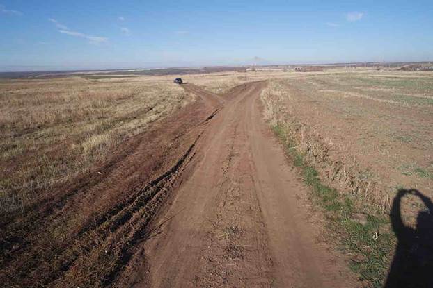
Figure 59 – At the Alleged Field Location of the Ukrainian BUK Deployment South of Zaroshchens’ke (photo taken from 47°59’01″N,38°27’03″E). Copyright
CORRECT!V, 2014
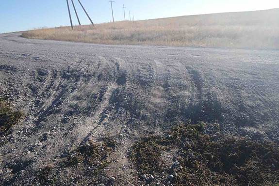
Figure 60 – At the Road Junction to the Field of the Ukrainian BUK Deployment South of Zaroshchens’ke (photo taken from 47°58’59″N,38°27’09″E). Copyright
CORRECT!V, 2014
Figure 59 is very interesting in showing apparent tracks leading into the fallow field on the left exact two positions Russia’s satellite picture shows a BUK in. Some of the tracks appear to be made by a dual tired vehicle, such as a low-loader trailer. It is unfortunate
that CORRECT!V seemingly did not follow the tracks and see where they lead, or explore the field. It is also interesting that CORRECT!V found two deep marks and that the ground was furrowed and turned over behind one of them. Had this been a launch location, the disturbance of the ground would have hid the evidence.
There are also some notable claims by the villagers recorded by CORREC!V.
No, she says, on July 17th she noticed nothing out of the ordinary. No unusual
noise, no condensation trails, no suspicious vehicles. Definitely not from the
Ukrainian army. “The Ukrainians weren’t here, they don’t dare come to these
parts.”
She was also in Zaroshchens‘ke on July 17th and did not notice anything. She
received an excited call from a relative in Moscow after the press conference.
But no: “All nonsense, nothing happened here.” Up until now they have been
spared from the war, only one rocket flew over the town at the end of July. “We
ran into the basement with the children,” a resident said.
The villagers gather on the street. Nobody saw anything, nobody heard anything. There was no BUK missile fired in Zaroshchens‘ke on July 17th 2014. Definitely not by the Ukrainian army because separatists control the fields around
Zaroshchens‘ke.
These eyewitness testimonies are interesting mainly in how misleading they are. The villagers claim the Ukrainian army was nowhere to be seen in the area in contradiction to the military reports of both the Militia and the ATO and social media posts of local residents where both of them speak of the Ukrainian Army having a large group centered on Bolshaya Shyshovka just 5 km to the east. It is also contradicts the known mechanized pincer attack on the H21 highway on July 27 undertaken by Ukraine.
The villagers claim war has spared the village. As we have seen just 2 km to the south around the village of Shaposhnykovo, which is the nearest settlement to Zaroshchens’ke, was intensively bombarded by Grad missiles fired by Ukraine immediately after Russia published satellite photos of the Ukrainian deployment to Zaorshchens’ke. Nearer to Zaroshchens’ke itself 4 small artillery craters can be seen in an elongated diamond pattern around this location: 47°58’50.32″N, 38°27’16.47″E. The area has clearly been intensely
fired by Grad missiles, mortars, and field artillery systems. Several fields around Zaroshchesn’ke also appear to have been burned during the fighting. One is the field east of the village next to the truck scale on the road to Molodets’ke and Shakhtersk. Another is the field just west of where the Russian MOD said the BUK TELAR’s lurked on July 17. All around the village, the neighboring settlements are scared by trenching, checkpoints, burned fields, craters, and artillery firing and spotting positions. When the villagers say that war has spared their settlement they are technically correct, but only because the devastation of war is instead spread out around them in all directions in the fields and other nearby settlements.
It is interesting that they do admit a rocket flew over their village, but allegedly on the wrong day to be related to MH17. Unfortunately the day of this occurrence is not provided, nor is it noted who fired the rocket or in which direction it flew or why it
was fired. But the memory of it remains.
CORRECT!V definitely got one point right:
The inhabitants of the separatists’ territory are afraid … They don’t want to say anything wrong.
So they seem to have told CORRECT!V what they thought they wanted to hear so that they would go away and other people would not bother them.
The report and interviews by Novaya Gazeta are even more problematic.
A small hill, recently plowed, is the place where, according to Russian military
experts, the “Buk-M1” missile was launched. The Russian military
experts claim that on July 17 the territory in the vicinity of the village and
this height was controlled by the armed forces of Ukraine (APU). However, six
local people told me that they didn’t see the Ukrainian Army in the village
during those days. According to them, Zaroshchens’ke on July 17 was under
control “DNR”, but the troops did not enter the village and there
were no battles here. …
The elevated place which the military experts claim could be used as a launch site
is the farmland of the family of a woman Natalia Viktorovna. Natalia
Viktorovna’s son shares the land with other residents. Last year (just like
this year), they planted this field. “We went there every day, and the day
after, and there was nothing there,” said Natalya Viktorovna. …[140]
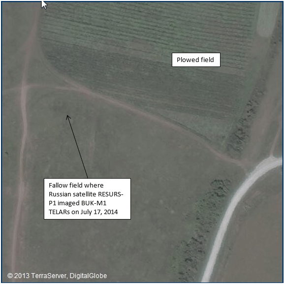
Figure 61 – Terraserver Preview Image, July 4, 2015 (47°59’00″N, 38°27’00″E) of field shown in Russian MoD image in Figure 2 of Ukrainian BUK-M1 TELAR’s south of Zaroshchenske. Note difference in plowed field to the north and fallow field to the south where the TELAR’s where imaged.
The location identified in the Russian satellite photos is not on a hill according to elevations provided by Google Earth. The launchers were placed on a long flat stretch of land 100 m wide at elevation 201 m above sea level, with the land in front for 375 m and behind for 425 m them at the same elevation. To their left, the land slopes downward and to the right it
rises up. It seems difficult to describe flat land as large 16 Football fields
laid side-to-side as a hill.
The location identified by Russian satellite photos was also not plowed in 2015 or 2014. The area is clearly visible in imagery on Terraserver.com[141] and shows no indication of any working by farm vehicles. The CORRECT!V investigator noted that it is an “overgrown field” as seen in Figure 58 showing a flat fallow field. It would seem the Novaya Gazeta reporter did not find the indicated spot and instead visited a different place, making their report of its features and interview of its users useless.
The Russian MoD and Almaz-Antey also did not say the missile was launched from the location on the satellite photo. The MoD only said BUK’s were located there on July 17th at 11:32 am Moscow time, while Almaz-Antey gave a larger area to the south and east as possible launch locations. It is entirely possible that the BUK-M1 vehicles relocated
southwards closer to Shaposhnykovo or even Mala Shyshovka prior to possibly firing. They are, after all, field-mobile air-defense systems.
Claims recorded in the article concerning control of the village are also confusing. Novaya Gazeta claims that the villagers thought there were no troops in their village. At the same time, Novaya Gazeta presents and heavily leans on the testimony of one witness claiming the DNR Militia had a checkpoint in the village, a local milkmaid, Natalia Nikolaevna:
NG: They say that the “Boeing” was allegedly fired at from your location here.
NN: This is nonsense! My husband went around by car, the tracks were
supposed to be theren, he drove around, checked everywhere, but there is not
even any trace! Even from a bicycle. How can you say that it was [fired] from
Zaroshchens’ke]? There was nothing! The most … the most perfect bullshit.
NN: We’d have heard if someone fired, but we didn’t here anything of this sort. Only later did we hear on TV!
NG: Did you have the “DNR Army” here?
NN: Yes, there was a checkpoint.
NG: And the Ukrainian army?
NN: Well they just passed by on the side, on that road.
NN: We all drove around and checked. No traces! All this nonsense
that “BUK” fired! We would have heard it, but we did not hear it.
NN: Only when some grenades flew by us did we hear that, but at that
time nothing was flying![142]
Apparently the different interviewers and villagers cannot keep the story straight. According to CORRECT!V’s villager, the Ukrainian Army wouldn’t dare come to the area,
except, of course when according to Novaya Gazeta’s villager they did and they passed right by the village even though there was a Militia checkpoint no one can see on satellite photos intended to stop them!
Several things may be said of the testimony recorded by Novaya Gazeta. CORRECT!V’s reporters apparently had no trouble finding the tracks of a tank like vehicle right on the road and two deep marks on the ground near where the Russians said two BUK’s had been located. Natalia says there is nothing because her husband went around and
couldn’t find it. There is no trace of any checkpoint anywhere near Zaroshchens’ke to be seen on Google Earth or Terraserver, and it seems unlikely the DNR would locate even a platoon of soldiers to this location as it provides no strategic advantage of any kind whatsoever that could not be better gained placing troops in more advantageous locations. The Ukrainian Army certainly did pass by on the road flanking Zaroshchens’ke to the east around July 27th, when they attacked Shakhtersk. This is the only witness featured in depth by Novaya Gazeta. They featured her, apparently thinking this made their case against the Russian MoD most strongly.
Another witness, Natalia Viktorovna, who was provided only on audio recording by Novaya Gazeta also contradicts Natalia Nikolaevna regarding the presence of the DNR Militia and a checkpoint.
NV: We had neither the DNR, nor the Nazis. Nobody was here in Zaroshchenske.
NG: The young man says that the village belonged to DNR.
NV: Not true. Nothing was here.
NG: The place was neutral?
NV: Nobody was here. We were here alone.
NG: And the Buk wasn’t here?
NV: Wasn’t.
The BBC Russia video is not much better. The reporter stands on the main road next to the entrance to Zaroshchens’ke about ¾ km from the BUK deployment site photographed by Russia. There is no evidence that he ever actually went to where the Russian MoD point to. He interviews a single older man who makes the same statements as Natalia Viktorovna.
Villager: There was no Ukrainian BUK here.
Villager: There was no weaponry. Even on the outskirts of the village.
Villager: No one saw any Ukrainian forces, nor any other forces.
The villagers and interviewers all seem to suffer from a form of the “Pauline Kael” syndrome.[143] Because they have not personally seen the BUK’s to their south in a field,
therefore they were not there, regardless of whether they might have only been
there for a few hours and simply gone unnoticed as people went about their
daily lives.
But most lacking in all of these interviews is any sense of interest in venturing into the field where the BUK’s supposedly stood to take photographs of the ground, or an interest in going south of the village into the countryside where the Ukrainian Army would have had to traverse to reach Zaroshchens’ke and where Almaz-Antey says it launched. No
one seems aware of the attack on Shaposhnykovo or why it suffered such massive
shelling. No one drives the routes a BUK would have needed to go to see what
it might have been like, where and who it might have passed, and who might have
seen it, or if anyone has pictures from July they might share. No one travels
to Blagodatnoe and Amvrosievka and ask locals if they might have seen BUK’s
moved around in July that could have gone to Zaroshchens’ke
So it must be asked if there is any evidence on social media that might be a trace of a BUK launch from this area. We can answer this in the affirmative. The first report on Twitter of the sounds of the MH17 shootdown is the following from a user in Torez who reports loud noises to his east.
July 17 – Twitter @other331 – July 17, 2014, 4:25 pm[144]
Что то нихуёво бахнуло со стороны Шахтерска – Something loud as hell just blasted from the direction of Shakhtersk
Thirty minutes later a pro-Ukrainian Twitter user providing English language translations of local social media reports writes that the plane was shot down from around Shakhtersk according to locals, not Snizhne:
July 17 – Twitter @ystirya – July 17, 2014, 4:55 pm[145]
Terrorists shot down Ukrainian plane near Thorez; locals say it was shot at from around Shakhtersk town.
Finally on VKontakte Overheard in Shkhtersk, a message board seemingly used predominantly by teenagers and young adults in 2014, people from Shakhtersk share the following observations within about one hour of the downing, and thus uncontaminated by later speculations broadcast on the internet and TV. These young people struggle to describe what they think they saw in the sky.
July 17 – Vkontakte Overheard in Shakhtersk – July 17, 2014, 5:12 pm[146]
Подслушано Шахтерск: В районе шахты “Прогресс” (Торез) упал
самолет. Предположительно АН-26. – A plane fell in the area of “Progess” Mine (Torez). Presumably an AN-26.
Valentin Ryapolov: Я думаю, что все это слышали. 2 выстрела а потом грохот. – I think I heard all of it, 2 shots and then the roar.
Подслушано Шахтерск replied to Valentin Ryapolov: Валентин, сначала
пилот скинул снаряды, что-бы ударной волной не задело их а
потом отлетели и катапультировались – Valentin, first the pilot fired off his ordinance so that they wouldn’t be hit by a blast wave, then they flew off and ejected.
Nikolay Zubchenko: Сначало самолет скинул снаряды а через 20 сек его сбили он упал возле шахты 4.9 – First the plane fired off his
ordinance and then it was shot down after 20 seconds and fell near Mine 4.9.
The last message is especially interesting because while the VKontakte user has seemingly confused the firing of the BUK missile and the crash of the plane with missiles fired by a plane which he could not possibly have seen given the cloud cover that day, he has correctly identified the interval of sounds a person in Shakhtersk roughly equidistant from the last Flight Data Recorder position south of Petropavlivka and from the
Zaroshchens’ke/Shaposhnykovo launch area would hear for MH17 being shot down by
a launch from south of their position in Shakhtersk – first a roar from the launch and then about 20 seconds later the blast of the warhead explosions at interception.
These observations of missiles in the air and a plane crash may also be mixed up with sightings of Ukrainian fighter planes people thought they saw around this time. While the presence of any Ukrainian warplanes has been controversial from the beginning, especially after the Russian MoD claimed detection of a Ukrainian aircraft near MH17 on their radar, there is an uncontaminated record of the presence of warplanes in the area from a discussion on VKontakte Overheard in Torez starting from around 2:50 pm on July
17, 2014 a full 90 minutes before the shootdown of MH17.[147] These people had no reason to report anything other than what they thought they were seeing and hearing – no one had any idea what would and did happen until several hours later.
Also given the distances involved, assuming a launch from the site identified by Bellingcat south of Snizhne could be even be heard 22 km away, people in Shakhtersk would have heard the sound of the launch simultaneously with the sound of the warhead explosion, so this observation cannot possibly fit to their theory. It is probably why Bellingcat claim’s
there are no witnesses of a launch near Shakhtersk. If you ignore data points that don’t fit your theory, you can pretend it is fully supported by all the evidence.
[2]
See http://www.segodnia.ru/content/143509
– Specifically:
Как сообщила пресс-служба российского оборонного ведомства, нашим специалистам
удалось зафиксировать работу украинской РЛС в день крушения малайзийского
самолета. Кроме того, вычислены населенные пункты Украины, откуда могли сбить лайнер.
В сообщении пресс-службы сказано прямо: маршрут самолета и место его падения
попадают в зону поражения двух украинских батарей зенитного ракетного комплекса
большой дальности и трех батарей ЗРК средней дальности “Бук-М1”.
“Российскими радиотехническими средствами в течение 17 июля фиксировалась
работа радиолокационной станции “Купол” батареи “Бук-М1”, дислоцированной
в районе населенного пункта Стыла (30 километров южнее Донецка)”, —
говорится в сообщении.
“При этом технические особенности “Бук-М1” позволяют осуществлять обмен
информацией о воздушных целях между батареями одного дивизиона. Таким
образом, пуск ракет также мог быть осуществлен со всех батарей,
дислоцированных в населенном пункте Авдеевка (8 километров севернее
Донецка) или Грузско-Зорянское (25 километров восточнее Донецка)”, —
указывает Минобороны России.
Translated:
According to the Russian Ministry of Defense press service, our specialists managed to locate working Ukrainian radar stations on the day of the crash of the
Malaysian plane. In addition, they determined settlements in Ukraine from where
the airliner could be shot down.
n the message of the press service it is plainly written: the route of the
aircraft and the place of its crash is within the kill zone of two Ukrainian
batteries of long-range anti-aircraft missile complexes [S-300] and three
batteries of medium-range SAM “Buk-M1”.
“Russian radio devices for 17 July recorded a working “KUPOL” radar battery
“Buk-M1”, stationed in the area of the settlement Styla (30
kilometers South of Donetsk)”, — stated in the message.
“Technical features of the “Buk-M1” allow the exchange of information on air
between batteries of the same division. Thus, the rockets could also be fired
by the batteries stationed in the settlement Avdiyivka (8 km North of Donetsk)
or Gruzko-Zoryanskoye (25 kilometers East of Donetsk),” says the Russian Defense Ministry.
Notably, the third battery location in range to the path of MH17 was not yet named. It would be revealed on July 21 to be at Zaroshchens’ke.
The Ukrainian BUK KUPOL radar control location at Styla is likely to be near the following location 47°45’42″N, 37°48’26″E. This was a Ukrainian Army field camp and artillery firing position until overrun by the Militia in late August, 2014. The remains of the camp can be seen on satellite imagery available on Terraserver.com from September 3, 2014. The
camp is correctly located to the position on the Russian MoD map north of Styla.
The Ukrainian BUK deployment location at Grzuko-Zoryanske is clearly visible on Google Earth imagery from July 16 to July 24, 2014 at the following location: 47°56’27”N, 38°04’16″E. During the sequence of the images, a large fortification is constructed including two of the characteristic Ukrainian Army standard issue field tents. We are not
aware of any use of such field tents by the Militia and have not found any location of one in our examination of satellite imagery in the Donbass. On the other hand, almost every known major field camp of the Ukrainian Army has these tents. The location is on the ridge of a hill near an appropriately named village of Vysoke. In imagery on Terraserver.com from October 8, 2014, the camp can be seen completed but abandoned by the Ukrainian Army. We know it is abandoned because Terraserver provided subsequent imagery up to July 20, 2015 shows little change in the camp, including abandoned vehicles remaining where left. The Gruzko-Zoryanske location was also protected by additional field works located at 47°56’24”N, 38°04’46″E and much more extensively at 47°55’22″N, 38°05’53″E. The second location can be seen as completed
on the October 8, 2014 Terraserver imagery. These field works protected the
approach to the fortification both from the Milita positions in nearby Ilovaisk as well as protecting the road access from this site to the Ukrainian checkpoint southwest of Mospyne on the road between Mospyne and highway T0509 near Sykove.
[4] See http://rt.com/news/173636-buk-malaysian-plane-crash/ – Specifically:
The Ukrainian military has several batteries of Buk surface-to-air missile systems with at least 27 launchers, capable of bringing down high-flying jets, in the Donetsk region where the Malaysian passenger plane crashed, Russian Defense Ministry said.
[5] Ibid. Specifically:
“According to the Russian Defense Ministry information, units of the Armed Forces of Ukraine
located near the crash-site are equipped with anti-aircraft missile systems of
“Buk-M1” … These complexes in their tactical and technical characteristics are capable of detecting air targets at ranges of up to 160 kilometers and hit them at full altitude range at a distance of over 30 kilometers,” the ministry’s statement reads as cited by RIA.
[8] This image was taken by the Russian satellite “Ресурс-П” №1. (RESURS-P1) at 11:32 am Moscow time. The identification was noted here: http://novosti-kosmonavtiki.ru/forum/forum12/topic14351/?PAGEN_1=26
by a Site Administrator with the handle “Liss”. Concerning the satellite
itself, see http://www.medeo-eu-ru.org/eo-online/index.php?lang=en&page=resourcep
and http://www.n2yo.com/satellite/?s=39186 and also the database at http://www.heavens-above.com/SatInfo.aspx?satid=39186&lat=0&lng=0&loc=Unspecified&alt=0&tz=UCT
[11] See http://www.ukrinform.ua/rus/news/kak_genshtab_rf_za_4_dnya_sfalsifitsiroval_snimki_po_boingu_1653774
[12]
The original Russian text is as follows:
Опозорились российские генералы и с другим “спутниковым
снимком, на котором изображена схема участка возле с.Зарощенское
Донецкой области, которую ГШ МО РФ определил как якобы
место пребывания ЗРК БУК-М1 (изображенный ими в увеличенном
квадрате).
“Грузовой вес ЗРК “Бук М1” со снаряжением – более 32 тонн. На
российских фотографиях – ни на больших, ни на маленьких
– следов заезда “Бук М1” на засеянную пшеницей территорию
нет, колеи не было ни с одной, ни с другой стороны. На фотографии
через несколько дней эти следы тоже не появились”, – отметил он.
Кроме того, разоблачению фальсификаций генштаба РФ помогла и
украинская страда: россияне, очевидно, не знали, что по состоянию на
16-17 июля показанные ими поля уже будут скошены.
“Поле, которое размещено юго-восточнее перекрестка №2 (обозначен на снимках за 16 число) – поле №1 – полностью скошено. И это за сутки
до якобы нахождения здесь “Буков”. На российской фотографии
мы видим, что поле лишь частично скошено, и это при том,
что фотография у них за 17 июля. То есть, за сутки до этого поле
было скошено, а на российских фотографиях оно еще не скошено. Такие
же признаки мы видим в верхней части под надписью: поле №2 так же
было скошено и есть четкие следы от тракторной техники, а на
российские фотографии этих следов нет”, – отметил В.Найда.
[14]
This is a subtle joke by Russia and jab at the competence of Ukraine in matters
of space imagery. Russia is pointing out the two imaging satellites launched
by Ukraine are not usable, as they malfunctioned soon after launch. See https://ru.wikipedia.org/wiki/Сич-1 and https://ru.wikipedia.org/wiki/Сич-2
[15]
See http://www.novayagazeta.ru/inquests/68332.html
and http://en.novayagazeta.ru/politics/68386.html
[17]
See (in Russian, with English subtitles) https://www.youtube.com/watch?v=uvxbrdm0wz0
[18]
See http://politinform.su/pervaya-polosa/29714-almaz-antey-o-krushenii-boinga-polnaya-versiya-prezentacii.html
[19]
See https://www.bellingcat.com/news/uk-and-europe/2015/07/13/zaroshchenske-launch-site-claims-and-reality-a-bellingcat-investigation/
[23]
See http://en.uos.ua/produktsiya/tehnika-pvo/75-zenitniy-raketniy-kompleks-buk
and https://www.youtube.com/watch?v=PiIxIGp_Nnk
[26]
See http://politikus.ru/events/14096-tri-zenitno-raketnyh-polka-vs-ukrainy-pereshli-na-storonu-vlastey-kryma.html
[32]
See (in Russian original) https://www.youtube.com/watch?v=Ri_D2Iz7EVw
and an English transcript http://www.liveleak.com/view?i=1fd_1421016527
[33]
See pictures of BUK TELAR 312 and TAR 301 at https://www.bellingcat.com/news/uk-and-europe/2015/01/05/is-this-ukrainian-buk-a-clue-in-the-mh17-investigation-or-a-red-herring/
[34]
See July 28, 2014 space image at http://www.terraserver.com/view.asp?cx=%2039.231847&cy=%2048.610171&proj=4326&mpp=0.75&sdrt=jax
[38]
See extensive destruction of the base and military vehicles on April 27, 2015
space image at http://www.terraserver.com/view.asp?cx=%2037.754042&cy=%2048.098229&proj=4326&mpp=0.75&sdrt=jax
[39]
A ground level picture of the 2 TELAR’s and 2 TEL’s left behind in Mariupol in
the motor pool area is available on vKontakte and appears to have been taken in
2013: see http://vk.com/photo-21385758_322548329
[41]
See http://russian.rt.com/article/37457
– a picture of the radar facility after the attack is here: http://jerry24-it.livejournal.com/184890.html
[42]
See http://vk.com/strelkov_info?w=wall-57424472_4486 – 29.06.2014,
17:17 (мск) Сообщение пресс-службы ДНР: “В Донецке бойцы спецподразделения
армии Донецкой народной республики захватили гарнизон ракетных войск,
зенитно-ракетный полк ПВО № А-1402″ – “Information from DPR Press Service, June
29, 2014 – Members of the special detachment of the Donetsk People’s Republic’s
army took control of the military garrison of [Ukrainian] missile defense
forces, to wit, anti-aircraft regiment No. A-1402.” (Translation by Gleb Bazov
on Slavyangrad.com)
[43]
See http://www.mil.gov.ua/news/2014/06/30/teroristi-ne-zahoplyuvali-bojovu-tehniku-chastin-protipovitryanoi-oboroni-zbrojnih-sil-ukraini-v-doneczku/
[44]
This statement is possibly not entirely accurate. As noted above, several BUK
units were left behind at each of the 156th Regiment’s bases. The
operational capability of these units is not clear.
[45]
See http://news.yahoo.com/photos/ukrainian-government-forces-maneuver-antiaircraft-missile-launchers-buk-photo-183322225.html
[46]
See https://www.youtube.com/watch?v=U2eGNPJlkMo
from 0:55 to 1:10.
[48]
See https://www.youtube.com/watch?v=Q3MomxNHnUA
between 4:45 and 4:54.
[49]
See http://cassad-eng.livejournal.com/29408.html#cutid1
and also detailed Ukrainian account
[51]
I.e. the ZSU-23-4 self-propelled anti-aircraft gun.
[52]
I.e. the 2K22 self-propelled anti-aircraft gun and missile launcher.
[53]
The BUK TELAR’s instrument panel provides a clear readout of target altitude,
speed, range, and direction. See picture and explanation here: https://www.facebook.com/photo.php?fbid=581440641995972.
This author does not agree with the conclusions of Mr. Lukashevich that
theoretical soldiers in a rebel BUK-M1 were under inordinate time pressure to
fire a missile and could not pay attention to such basic data. After all, an
AN-26 or IL-76 is not armed with air-to-ground missiles to attack a BUK, so
there are several minutes from the moment of detection to confirm the target is
military without fear of the BUK being destroyed by emitting radar signals.
[63]
See http://www.dailymail.co.uk/news/article-2701700/Is-BUK-missile-launcher-downed-flight-MH17-Startling-new-picture-emerges-gun-toting-pro-Russian-separatist-posing-military-hardware-Ukraine.html
[65]
In Russian; in Ukrainian it is called Velyka Shyshivka
[66]
In Russian; in Ukrainian it is called Blahodatne
[72]
See http://www.rbc.ru/rbcfreenews/20140707202705.shtml?utm_source=dlvr.it&utm_medium=twitter#xtor=AL-%5Binternal_traffic%5D–%5Brss.rbc.ru%5D-%5Btop_stories_brief_news%5D
[87]
The Ukrainian Government generally refers to the Self-Defense Militia of the
DNR and LNR as “terrorists.”
[91]
See http://voicesevas.ru/news/yugo-vostok/2887-voyna-na-yugo-vostoke-onlayn-16072014-hronika-sobytiy-post-obnovlyaetsya.html.
[92]
Ukrop (or Ukr or Ukie) is a derisive slang term of the Militia for the
Ukrainian Armed Forces and National Guard. Without endorsing its use, it is
transliterated here as it is written.
[95]
See http://mungaz.net/line/14639-nochyu-proizoshli-zhestokie-boi-na-vostoke-doneckoy-oblasti-video.html
In the original Russian:
Под Донецком ночью шел тяжелый бой Сегодня ночью, 16 июля, ожесточенные
боевые столкновения произошли в районе Шахтерска и Амвросиевки.
Вначале в интернете появились видео, где колонна бронетехники выезжает из Донецка в
сторону Шахтерска. По сообщениям жителей Тореза и Шахтерска, затем начались активные
боевые действия в их районе, пишет Муниципальная газета. «Украинская авиация
накрыла колонну бронетехники», «в Шахтерске окна трясутся», «началась бомбежка возле
Тореза в р-не Саур-могилы! Возможно работает «Град», «бомбят за Торезом в стороне Саур-могилы!
Чуть правее, чем обычно. Видны залпы», «Б.Шишовка – мощный бой, все в огне. Инфа от шахтерцев,
смотрят с мкрн.», «с копра шахты Прогресс в Торезе над 20-й видны огни и залпы», – писали
пользователи соцсетей.
[96]
The convoy was discussed on VKontakte Overheard in Shakhtersk. See https://vk.com/wall-63034346_45329
Part of this convoy was filmed by local residents in Shakhtersk. The video
includes a tank, 2 BTR, a Strela-10, three D-30 towed artillery, and numerous
trucks and cars before it ends. See https://vk.com/wall-70279965?offset=37580&own=1&z=video141146249_169993706%2F9fb9d12694e3d5066d
[117]
See https://burkonews.info/terrorist-war-russian-federation-ukraine-eastern-front-summary-august-22-2014/
[138]
The authors of CORRECT!V have obviously conflated the S-300 missile system
(where the missile launcher has 4 containers) and the BUK-M1 system (where the
missiles are launched in the open).
[140]
In the Russian original: Небольшая возвышенность, недавно вспаханная, — это и есть то место, откуда, по заключениям российских военспецов, производился
запуск ракеты «Бук-М1». Военспецы РФ уверяют, что 17 июля территорию в
окрестностях поселка и эту высоту контролировали вооруженные силы Украины
(ВСУ). Однако шесть местных жителей рассказали мне, что украинской
армии в поселке в те дни не видели. По их словам, Зарощенское 17 июля
находилось под контролем «ДНР», но сами войска в поселок не заходили, не
было здесь и боев. …
Высота, с которой, по утверждениям военспецов, мог быть осуществлен запуск,
является пахотным угодьем семьи Натальи Викторовны. На паях с другими
жителями сын Натальи Викторовны распоряжается высотой. В прошлом году
(как и в этом) они засеивали свой участок. «Ездили туда каждый день, через день, и ниче там не стояло, — рассказывает мне Наталья Викторовна …».
[141]
See relatively unchanging imagery from March 20, March 25, April 28, July 4,
and July 20, 2015 available on Terraserver.com at the following link: http://www.terraserver.com/view.asp?cx=%2038.449866&cy=%2047.983410&proj=4326&mpp=0.75&sdrt=jax
[142]
In the Russian original:
—
Говорят, будто бы стреляли по «Боингу» отсюда, от вас.
— Это глупости! Муж у меня объехал на машине, следы же должны были остаться, он проездил, все просмотрел, но там нет даже никакого следа! Даже от велосипеда.
Как можно сказать, что из Зарощенского [стреляли]? Ниче не было! Самая …
брехня, самая настоящая.
— Мы бы слышали, если бы кто-то стрелял, а мы ничего не слышали такого.
— Потом только по телевизору услышали!
— Здесь у вас была «ДНРовская» армия?
— Да, там был блокпост.
— А украинская армия была?
— Ну они прошли стороной, по той дороге.
— Все мы проездили, просмотрели. Никаких следов! Все это ерунда, что «Бук»
стрелял! Мы бы слышали, а мы не слышали.
— Только когда через нас летали эти самые гранаты, мы слышали, а тогда ниче не
летало!
An alternate translation is also available here: http://uatoday.tv/politics/mh17-tragedy-witnesses-refute-russia-theory-of-ukrainian-buk-missiles-434973.html and Interpetermag has yet another translation here: http://www.interpretermag.com/there-was-no-buk-in-our-field/ with a few not so innocent mistranslations included, such as translating “ПЗРК”
– “MANPADS” as “MLRS” – “Multiple Launch Rocket Systems” which is meant to
imply in the mind of the reader a nonexistant original Russian of “ЗРК”
– “SAM” – “Surface to Air Missile”.